Point of Beginning, U.S. Public Lands
Society
Main Category
Sub Category
Era
Date Created
Location Country
us
Coordinates
40.642392, -80.519378
Address2
Harvey Avenue
City
East Liverpool
State
Country
Zip

The "Land Ordinance of 1785" required that U.S. lands in the public domain be surveyed before sale, and that the surveys be made in accordance with a consistent, integrated system of lines grid-oriented to a true meridian (north-south reference line) and base line (east-west reference line), subdividing the land into approximately square parcels, called townships.  

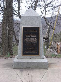
Thomas Hutchins, the first Geographer of the United States, drove his stake near East Liverpool, Ohio to mark the Point of Beginning of the Geographer's Line, the first westward base line.

The surveys were required by the ordinance to begin "... on the Ohio River at a point that shall be found to be due north from the western termination of a line which has been run as the southern boundary of the state of Pennsylvania." This point was chosen because the southern boundary of Pennsylvania had just been surveyed, but the western boundary had not.

The Point of Beginning survey, an original undertaking, was completed under extremely trying conditions and with primitive instruments and techniques. It resulted in the "seven ranges" of Ohio, which provided the basis for similar frameworks for the disbursement of public lands in 30 other states.
Image Credit
Courtesy Wikipedia/Nyttend
Image Caption
This monument marks the site that served as the basis for the entire Public Land Survey System — the system by which most of the United States, outside of the original colonies, was surveyed.

We hope you enjoyed this essay.

Please support America's only magazine of the history of engineering and innovation, and the volunteers that sustain it with a donation to Invention & Technology.

Donate

Stay informed - subscribe to our newsletter.
The subscriber's email address.