
Until 1900, the Chicago River drained into Lake Michigan, along with all the sewage from the city; and the Des Plaines River west of Chicago emptied into the Illinois River, which eventually flows to the Mississippi. Chicago residents drew their drinking water from polluted areas of the lake near the mouth of the Chicago River, leading to outbreaks of typhoid and other waterborne diseases.
Water Supply & Control
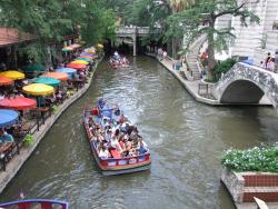
San Antonio's River Walk, a catalyst for abundant commercial and tourism enterprise, is generally regarded by cities and urban planners throughout the world as a prototype for the development of urban riverfront sites. The River Walk's success, however, would not have been possible without a series of flood-control and architecture projects completed in the first half of the 20th century that relied heavily on civil-engineering expertise.
YearAdded:
Image Credit: Courtesy Flickr/Tim Pearce (CC BY 2.0) Image Caption: San antonio texas river walk 2011 riverwalkEra_date_from: 1929
1996
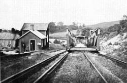
Morris Canal was built to transport coal from the Lehigh Valley of Pennsylvania to industrial markets in Newark and New York. The total length of the canal was 106 miles. The canal climbed an astonishing 914 feet from Newark Bay to the summit at Lake Hopatcong, and then dropped 760 feet to the Delaware River at Phillipsburg. This gave the canal an average vertical slope of 18 feet per mile, steep compared to the contemporary Erie Canal's relatively gentle slope of one foot per mile.
YearAdded:
Image Credit: Courtesy ASCEImage Caption: The Hydraulic-Inclined Plane System gave the Morris Canal an average vertical slope of 18 feet per mile. Era_date_from: 1824
1979
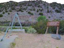
A tiny village on the Rio Grande River in northern New Mexico became the training center for the first American hydrographers and provided the first stream-gauging operations of the U.S. Geological Survey. To plan any water system, it is necessary to know the amount of water flowing in the stream or river at all times - including low, normal, and flood conditions.
YearAdded:
Image Credit: Courtesy Wikicommons/Chris English (CC BY-SA 3.0)Image Caption: Near Velarde, NM: U.S. Geological Survey Rio Grande Embudo Gaging Station, 2011Era_date_from: 1888
1973
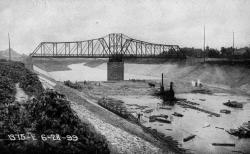
Society: ASCEMain Category: CivilSub Category: Water Supply & ControlEra: 1870-1879DateCreated: 1875-1879New OrleansState: LAZip: 70113Country: USAWebsite: http://www.asce.org/Project/Eads-South-Pass-Navigation-Works/Creator: Eads, James Buchanan
"Eads had to succeed in the face of conventional wisdom which doomed him to disaster. Entrenched authorities not only completely dismissed his theories, but pointed to the indifferent European experiences with what he proposed."
- ASCE Landmark Nomination Proposal, 1982
YearAdded:
Era_date_from: 1875
1982
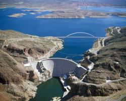
The first electric power generated by the Theodore Roosevelt Dam for commercial use was transmitted over a high-voltage line to Phoenix, where it was employed to operate the city's new streetcar system.
YearAdded:
Image Credit: Courtesy Bureau of Reclamation (CC BY-SA 2.0)Image Caption: Theodore Roosevelt DamEra_date_from: 1911
1970

After an initial difficulty in attracting customers (who were used to getting their water from public pumps and private wells and cisterns), Philadelphia's waterworks soon couldn't keep up with demand. John Davis and Frederick Graff designed a complete remodeling of the system in 1811 so that it could supply the city's growing needs.
YearAdded:
Image Credit: Public Domain (National Park Service)Image Caption: Philadelphia Municipal Water SupplyEra_date_from: 1801
1974
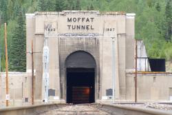
Known as "the highest and lowest holing in history," the tunnel bored through the Rockies at an elevation of 9,200 feet, 2,800 feet below the surface. Eight hundred men worked around the clock for 3 1/2 years, moving 3 billion pounds of rock.
YearAdded:
Image Credit: Courtesy Flickr/Bradley Gordon (CC BY 2.0)Image Caption: Moffat TunnelEra_date_from: 1928
1979
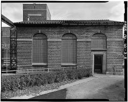
This was America's first large-scale activated sludge plant. The successful operation of Milwaukee's sewage treatment plant led the way for many other American municipalities to adopt its methods of efficient environmental recycling.
Prior to 1925, sewage and industrial waste from the City of Milwaukee and its suburbs (then population 500,000) was discharged to the Milwaukee, Menomonee, and Kinnickinnic rivers, which converge in Milwaukee and flow together through a single outlet into Lake Michigan.
YearAdded:
Image Credit: Public Domain (National Park Service)Image Caption: Milwaukee Metropolitan Sewage Treatment PlantEra_date_from: 1919
1974
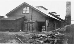
The city of Shreveport could not justify the cost of building a water distribution system solely for the purpose of supplying potable water. It was a series of disastrous fires in the 1880s that galvanized support for a pumping facility that would provide ample water for firefighting.
YearAdded:
Image Credit: Public Domain (National Park Service)Image Caption: McNeill Street Pumping StationEra_date_from: 1887
1999
Innovations
Four prehistoric reservoirs at Mesa Verde National Park were constructed and used between AD 750 and AD 1180. They are: Morefield Reservoir (in Morefield Canyon), Far View Reservoir (on Chapin Mesa), Sagebrush Reservoir (on an unnamed mesa), and Box Elder Reservoir (in Prater Canyon). These four…
Read More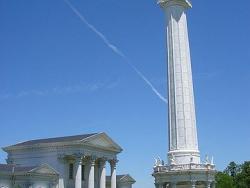
In the 18th century, French architect Claude-Nichols Ledoux was known for forging architectural beauty with industrial efficiency. One hundred years later his vision was given new life through the design of the Louisville Water Company Pumping Station. Inspired by Ledoux's Royal Salt Works at…
Read More
In the mid-1800s Virginia City was America's greatest producer of high-grade silver and gold ore. When mining activities began, natural springs provided water to the camps. As the population grew, the Virginia and Gold Hill Water Company was formed to address the need for more water. The company…
Read More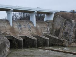
The Miami Conservancy District flood control project was the direct result of the disastrous flood of 1913, when waters from the Miami, Stillwater, and Mad rivers flooded Dayton and surrounding communities in the Miami Valley. More than 400 lives were lost and property damage exceeded $100…
Read More
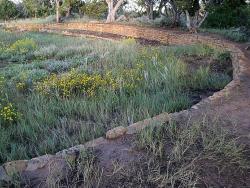
This is one of the earliest uses of engineered water supply and irrigation systems in the United States. The first of eight original acequias was under construction in 1718 and two are still in operation. The remains of one are visible on the grounds of the Alamo. The Acequias of San Antonio are…
Read More
The roman emperor Trajan ordered a new aqueduct be built to bring fresh water to Italy's Trastevere region and parts of Rome. The water is collected from five springs that feed the lake at Bracciano, and traverses over 25 miles into Rome. To maintain an even gradient, the aqueduct follows a…
Read More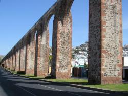
Queretaro's aqueduct, in Central Mexico, is one of the most eloquent symbols of colonial Mexico. As one of the early major hydraulic engineering projects in North America, it defines the city both nationally and internationally. The aqueduct, designed in 1723 by Juan Antonio de Urrutia y Arana,…
Read More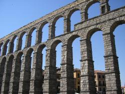
For 2,000 years, Aqueducto de Segovia has been conveying drinking water from the Frio River to Segovia, approximately 18 kilometers away. Built under the reign of Roman emperor Trajan, the aqueduct is one of the most intact and best-preserved Roman engineering masterpieces. Roman engineers built…
Read More
Belle Fourche, meaning "Beautiful Forks" in French, refers to the confluence of the Redwater and Belle Fourche Rivers. The gold rush to the Black Hills in 1876 brought many people to the area, but agriculture and livestock soon became the principal industries. Farmers and civic leaders…
Read More
The first known pumping system providing drinking and wash water in the North American colonies. The building (still standing) is dated 1761, but it was preceded by an experimental frame building dated 1754. Before the Bethlehem built its system, assigned carriers would daily haul water up the…
Read More
Cabin John Aqueduct, designed by Montgomery C. Meigs, conveys drinking water from Great Falls, Maryland to Washington, D.C. It was the longest stone masonry arch in the world for nearly 40 years. The segmental arch of the bridge has a span of 220 feet and a rise of only 57 feet. The main arch…
Read More
Clarifying the turbid waters of the Mississippi River for use as drinking water was a formidable challenge. The Chain of Rocks Water Purification Plant provided the first application of a system of flocculation, sedimentation, and rapid sand filtration for water purification.
The system…
Read More
Stretching 242 miles from the Colorado River on the California-Arizona border to its final holding reservoir near Riverside, California, the Colorado River Aqueduct consists of more than 90 miles of tunnels, nearly 55 miles of cut-and-cover conduit, almost 30 miles of siphons, and five…
Inferior water and the lack of a sufficient water supply prompted public pressure to find a significant water source for the 360,000 of people living in New York City at the time. Studies determined that the Croton River, 40 miles north of the city, was the best available source. The original…
Read More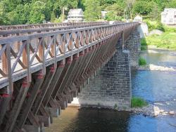
The Delaware Aqueduct provided an important transportation link between the Pennsylvania's coalmines and New York's booming industrial marketplace. It is the earliest surviving work of John A. Roebling, who designed the Brooklyn Bridge 30 years later. The cable anchorage system first used…
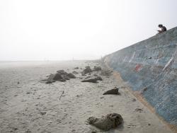
Galveston Island is a barrier island located two miles off the Texas coast. The island is about 3 miles wide at its widest and about 28 miles long. The Galveston Seawall extends over 10 miles along Galveston's oceanfront, protecting life and property against hurricanes and tropical storms. …
Read More
Originally known as the Coolgardie Goldfields Water Supply Scheme, the Goldfields Water Supply, Western Australia, has exceptional and unique cultural significance for Australia. Western Australia's first Premier, the dynamic and visionary Sir John Forrest, recognized the need for this…
Read More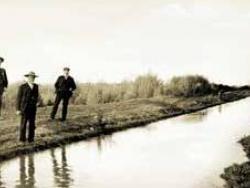
Developed by the Hohokam, a prehistoric group of Native Americans, the canal system in the Salt River Valley serviced more than 100,000 acres of mostly arid desert country in what is now southern Arizona. The prehistoric Hohokam constructed one of the largest and most sophisticated irrigation…
Read More
Frank Zybach, a tenant farmer and inventor living near Strasburg, Colorado, received a patent for a "Self-Propelled Sprinkling Irrigating Apparatus" on July 22, 1952.
The device used mobile towers to continuously move a pipeline in a circle around a pivot. Water was supplied through the pivot and… Read More

The Charles River Basin was one of the pioneering environmental engineering projects in America. The project transformed 675 acres of unhealthy and unsightly salt marshes and tidal flats were into an environmental centerpiece for the Boston area by 1910. This was one of the first public projects…
Read More