
The voyage of Captain George Vancouver, 1791 -1795, was commissioned by the British Admiralty to map in detail the west coast of North America from Mexico to Alaska and to meet with Spanish authorities on the coast to enforce the terms of the Nootka Sound Convention of 1790.
Departing Falmouth, England, in April 1791 in the flagship Discovery and tender Chatham, Vancouver arrived off Cape Mendocino one year later. During the next three summers his expedition mapped the coastline from latitude N 30 degrees in Mexico to N 60 degrees at Cook Inlet, Alaska. Because of the extremely broken nature of the northern half of the coastline, Vancouver was required to perform much of the survey by small boats, which traversed 10,000 miles exploring and mapping every navigable inlet. One of the primary purposes was to prove, or disprove, once and forever the existence of a Northwest Passage through temperate North America.
The project required extraordinary technical and management skills to establish accurate geographical positions and to organize and motivate survey crews in a wild and harsh environment thousands of miles and many months from home.By the time the survey was completed, Vancouver's large ships had traveled 65,000 miles, ten thousand miles more than Captain Cook's second voyage. This was possibly the longest and most arduous sea voyage on record at the time.
Vancouver's negotiations with local Spanish authorities were much less successful. However, despite his many differences with Juan Francisco de la Bodega y Quadra, the local Spanish commander, over the terms of the Nootka Sound Convention, the two men developed a very warm relationship. This resulted in some joint survey efforts by the Spanish and English parties and the sharing of survey information that saved the English many hours by not having to survey many of the islands off what is now British Columbia.
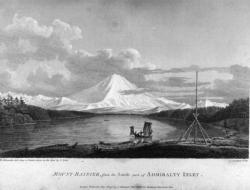
Vancouver's survey resulted in the most accurate and detailed map of its time for the entire west coast of North America, and proved conclusively the absence of a Northwest Passage through the continent. Vancouver was the first European to discover and map Puget Sound and to prove the insularity of Vancouver Island.
His charts were so comprehensive and accurate that they were in use by mariners in Alaska in the 1890s, nearly 100 years after being published. His maps, and those of the Spanish, also served as important references during settlement of the international boundary disputes between Great Britain and the United States in 1846 and 1872.
Resources:
- Anderson, Bern (1960). Surveyor of the Sea: The Life and Voyages of Captain George Vancouver; University of Toronto Press; Toronto.
- Fisher, Robin (1992). Vancouver's Voyage: Charting the Northwest Coast, 1791-1795 ; University of Washington Press, Seattle.
- Fisher, Robin & Johnston, Hugh J. M. (Editors) (1993). From Maps to Metaphors: The Pacific World of George Vancouver ; University of British Columbia Press.
- Lamb, W. Kaye (editor) (1984). The Voyage of George Vancouver 1791-1795 ; Hakluyt Society; London.
- Meany, Edmund (1915). Vancouver's Discovery of Puget Sound ; Macmillan Company; New York.
- Pipes, Nellie B. (1933). The Memorial of John Mears to the House of Commons Respecting the Capture of Vessels in Nootka Sound ; Metropolitan Press; Portland, Oregon.
- Whitebook, Robert B. (1959). Coastal Explorations of Washington ; Pacific Books; Palo Alto; California.
- Wing, Robert C. and Newell, Gordon (1979). Peter Puget ; Gray Beard Publishing; Seattle.
