
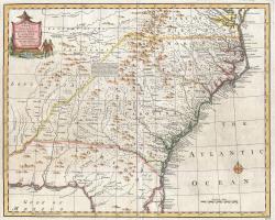
The Royal Colonial Boundary of 1665 was decreed by England's King Charles II to demarcate his American colonies. It provided a survey from the Atlantic Ocean to the Mississippi River along 36 degrees, 30 minutes north latitude. The boundary now serves to divide Virginia from North Carolina and Kentucky from Tennessee.
Cadastral
YearAdded:
Image Caption: Emanuel Bowen's 1747 map showing the boundary between Virginia and North Carolina.Era_date_from: 1728
1985
Innovations
The Royal Colonial Boundary of 1665 was decreed by England's King Charles II to demarcate his American colonies. It provided a survey from the Atlantic Ocean to the Mississippi River along 36 degrees, 30 minutes north latitude. The boundary now serves to divide Virginia from North Carolina and…
Read More