
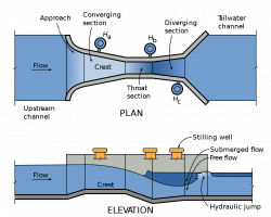
Since the beginning of irrigated agriculture, it has been important to measure flows of irrigation water. Accuracy of early water measurement methods often suffered because of trash or sediment in the water, or unusual flow conditions. Ralph L. Parshall saw this problem when he began working for the USDA in 1915, as an irrigation research engineer. In 1922 he invented the flume now known by his name. When this flume is placed in a channel, flow is uniquely related to the water depth.
1985
YearAdded:
Image Credit: Public Domain
1985
The "Land Ordinance of 1785" required that U.S. lands in the public domain be surveyed before sale, and that the surveys be made in accordance with a consistent, integrated system of lines grid-oriented to a true meridian (north-south reference line) and base line (east-west reference line), subdividing the land into approximately square parcels, called townships.
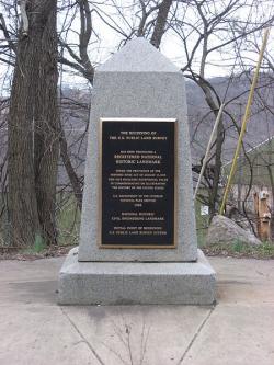
Thomas Hutchins, the first Geographer of the United States, drove his stake near East Liverpool, Ohio to mark the Point of Beginning of the Geographer's Line, the first westward base line.
YearAdded:
Image Credit: Courtesy Wikipedia/Nyttend Image Caption: This monument marks the site that served as the basis for the entire Public Land Survey System — the system by which most of the United States, outside of the original colonies, was surveyed.Era_date_from: 1785
1985
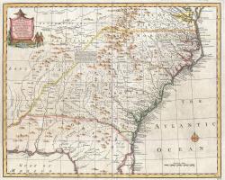
The Royal Colonial Boundary of 1665 was decreed by England's King Charles II to demarcate his American colonies. It provided a survey from the Atlantic Ocean to the Mississippi River along 36 degrees, 30 minutes north latitude. The boundary now serves to divide Virginia from North Carolina and Kentucky from Tennessee.
YearAdded:
Image Caption: Emanuel Bowen's 1747 map showing the boundary between Virginia and North Carolina.Era_date_from: 1728
1985
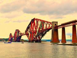
"The majestic Forth Bridge ... symbolises the tremendous achievements of Victorian engineers and the immense strides made in the technique of bridge design and construction since the dawn of the Railway Age..."
- Derrick Bennett, Bridges: Great Buildings of the World
YearAdded:
Image Credit: Courtesy Flickr/Brain M Forbes (CC BY 2.0)Image Caption: The Forth Bridge became the longest bridge in the world when it was completed in 1890.Era_date_from: 1890
1985

Sculptor Frederic-Auguste Bartholdi is credited with bringing the concept of the Statue of Liberty to fruition, deriving inspiration from the 19th-century penchance for grandiose monuments. He originally designed the statue for placement at the Suez Canal, but the project was never commissioned. After a promotional trip across America, Bartholdi's ideas finally took hold in 1874, and a Franco-American coalition was formed to fund the project, with the Americans building the base and the French the statue.
YearAdded:
Image Credit: Public Domain (U.S. Customs and Border Protection)Image Caption: Statue of LibertyEra_date_from: 1886
1985
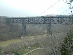
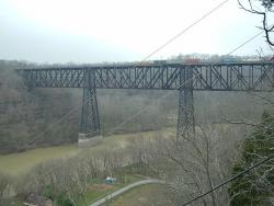
In the 1850s, the Lexington and Danville Railroad began building a suspension bridge over the Kentucky River. The bridge was designed by John A Roebling. Due to unforeseen increases in train loads, the Roebling bridge was never completed. The High Bridge would then be built 20 years later on the existing foundations.
YearAdded:
Image Credit: Public Domain (Author's Choice)Image Caption: High BridgeEra_date_from: 1877
1985

The Jake Brake permits large trucks to descend long, steep grades at a controlled speed. It was the first practical mechanism for altering on demand the valve timing on a truck diesel engine, thereby converting the engine to a power absorbing machine. The modified engine can continue to power the truck in normal operation, allowing service brakes to remain cool for emergency situations. Invented by Clessie Lyle Cummins (1886-1968), this device (produced by the Jacobs manufacturing company since 1961) has contributed significantly to highway safety.
YearAdded:
Image Credit: Courtesy Wikipedia/Sierra Fournier (CC BY-SA 3.0)Image Caption: Jacobs Engine Brake Retarder ("Jake Brake")Era_date_from: 1957
1985
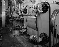
This 350-horsepower Corliss type steam engine is an example of a typical late nineteenth century steam engine. The essential feature of Corliss type engines is the valves that admit steam to and exhaust it from the cylinder. The Corliss valve gear made the engine extremely efficient in steam consumption and was the most efficient system for controlling low to medium speed engines.
This particular engine operated for more than eighty years, having been retired not by age but over concern for stack emissions by the U.S. Environmental Protection Agency. The engine was built by the William A.
YearAdded:
Image Credit: Public Domain (National Park Service)Image Caption: Harris-Corliss Steam EngineEra_date_from: 1895
1985
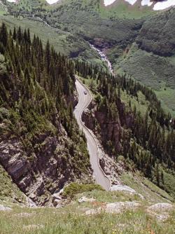
Considered one of the world's most scenic mountain drives, the two-lane Going-To-The-Sun Road through Glacier National Park was the first major road to be constructed directly over high mountain terrain, proving that roads did not need to be limited to mountain passes.
YearAdded:
Image Credit: Original Image: Flickr/Katie BradyImage Caption: Going-to-the-Sun RoadEra_date_from: 1932
1985
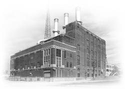
The concept of heating a number of buildings in the core area of a city from a single heating plant was introduced into the United States by Birdsill Holly at Lockport, New York, in 1877. The gain in thermal efficiency of a single large steam plant over a series of small isolated boilers led to widespread commercial installation of district heating. Organized by the Detroit Edison Company, the Central Heating Company began service here in 1903, supplying twelve customers with steam piped from the Edison Company's Willis Avenue Plant. Today's greatly enlarged system continues in operation.
YearAdded:
Image Credit: Courtesy ASMEImage Caption: Detroit Edison District Heating SystemEra_date_from: 1903
1985
Innovations
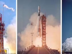
The Atlas E-2 Space Booster, or launch vehicle, is a modified intercontinental ballistic missile developed by the Convair Division of General Dynamics and the U.S. Air Force. The basic concept of the Atlas system was proven in its first flight on June 11, 1957, followed over the years by the… Read More
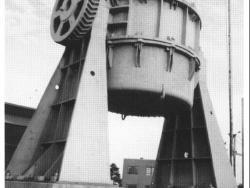
This is one of the three original 60-ton vessels by which the basic oxygen process (BOP) of steel making was introduced into this country from Austria, where it was invented. It heralded the first new technology in fifty years to become the basis of a major process for steel production throughout… Read More

The longest steel-arch bridge in the world for 46 years, the Bayonne Bridge continues to be celebrated today as a major aesthetic and technical achievement. The 1,675-foot bridge replaced a ferry service which until then was the only means of crossing from the Bayonne peninsula to Staten Island…
Read More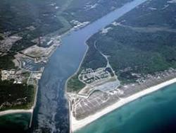
The idea of a canal eliminating the costly and dangerous sea trip around the Massachusetts peninsula of Cape Cod was envisioned as early as 1623 by Pilgrim leader Miles Standish. It was not until financier August Belmont became involved in 1906, however, that sufficient funds for the project…
Read More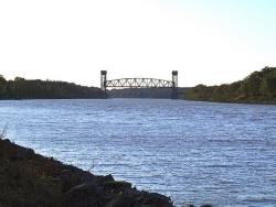
The Chesapeake & Delaware Canal is the only canal built in 19th-century America that still operates today as a major shipping route. Connecting the Port of Baltimore and Upper Chesapeake Bay with the mouth of the Delaware River and the Port of Philadelphia, the canal was one of the first…
Read More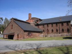
When erected by Peter Grubb to smelt the rich iron ore of the nearby Cornwall ore banks, this stone-built blast furnace was typical for its time, producing about 20 tons of pig-iron and cast-iron products a week. A major reconstruction in 1856 to 1857 produced important changes: the furnace itself… Read More
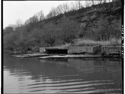
Before the Davis Island Lock & Dam were built, the flow of the Ohio River slowed to little more than a trickle during dry periods. For several months each year, the unreliable flow stranded Pittsburgh's steamboats, towboats, and barges.
The Davis Island Lock &…
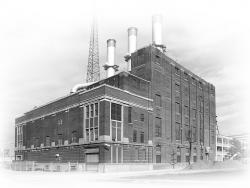
The concept of heating a number of buildings in the core area of a city from a single heating plant was introduced into the United States by Birdsill Holly at Lockport, New York, in 1877. The gain in thermal efficiency of a single large steam plant over a series of small isolated boilers led to…
Read More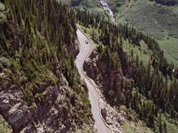
Considered one of the world's most scenic mountain drives, the two-lane Going-To-The-Sun Road through Glacier National Park was the first major road to be constructed directly over high mountain terrain, proving that roads did not need to be limited to mountain passes.
Glacier National…
Read More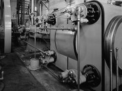
This 350-horsepower Corliss type steam engine is an example of a typical late nineteenth century steam engine. The essential feature of Corliss type engines is the valves that admit steam to and exhaust it from the cylinder. The Corliss valve gear made the engine extremely efficient in steam… Read More
The Jake Brake permits large trucks to descend long, steep grades at a controlled speed. It was the first practical mechanism for altering on demand the valve timing on a truck diesel engine, thereby converting the engine to a power absorbing machine. The modified engine can continue to power the… Read More
In the 1850s, the Lexington and Danville Railroad began building a suspension bridge over the Kentucky River. The bridge was designed by John A Roebling. Due to unforeseen increases in train loads, the Roebling bridge was never completed. The High Bridge would then be built 20 years later on the…
Read More
Sculptor Frederic-Auguste Bartholdi is credited with bringing the concept of the Statue of Liberty to fruition, deriving inspiration from the 19th-century penchance for grandiose monuments. He originally designed the statue for placement at the Suez Canal, but the project was never commissioned…
Read More
"The majestic Forth Bridge ... symbolises the tremendous achievements of Victorian engineers and the immense strides made in the technique of bridge design and construction since the dawn of the Railway Age..."
- Derrick Bennett, Bridges: Great Buildings of the World
Throughout…
Read More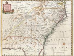
The Royal Colonial Boundary of 1665 was decreed by England's King Charles II to demarcate his American colonies. It provided a survey from the Atlantic Ocean to the Mississippi River along 36 degrees, 30 minutes north latitude. The boundary now serves to divide Virginia from North Carolina and…
Read More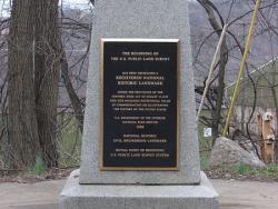
The "Land Ordinance of 1785" required that U.S. lands in the public domain be surveyed before sale, and that the surveys be made in accordance with a consistent, integrated system of lines grid-oriented to a true meridian (north-south reference line) and base line (east-west reference line),…
Read More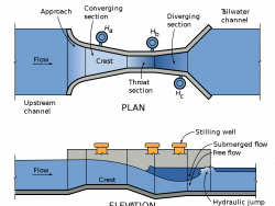
Since the beginning of irrigated agriculture, it has been important to measure flows of irrigation water. Accuracy of early water measurement methods often suffered because of trash or sediment in the water, or unusual flow conditions. Ralph L. Parshall saw this problem when he began…
Read More