
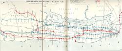
In the 19th century, New York City was a burgeoning industrial and commercial metropolis - the largest city in the United States and second largest in the world. As the city's population increased, people began to call for construction of an underground railway. Many unusual engineering challenges had to be overcome, not the least of which was construction in a dense urban area. After lengthy legal battles over property rights and the debt limit of the city, ground was broken on March 24, 1900.
Roads & Rails
YearAdded:
Image Credit: Courtesy Wikipedia/Interborough Rapid Transit Company Image Caption: A map of New York's first underground subway.Era_date_from: 1900
1977
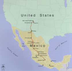
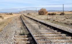
El Camino Real (literally, "the royal road") is the oldest and longest historical trail in the Western Hemisphere. The transportation link has, through the centuries, been called various names, including El Camino Real de Tierra Adentro (literally, "the road to the interior" because the U.S. frontier was seen as the country interior to Mexico), the King's Highway and the Royal Highway. It became a transportation lifeline that helped integrate Spanish and European culture in the Southwestern U.S.
YearAdded:
Image Credit: Courtesy Wikipedia/National Park ServiceImage Caption: El Camino Real (literally, "the royal road") is the oldest and longest historical trail in the Western Hemisphere. Era_date_from: 1519
1986
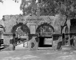
Historically, a camino real (Royal Road) is defined as a road that connects Spanish capital with Spanish capital, a distinction not shared with roads connecting ordinary Spanish or Indian villages. The term Camino Real implied that the status and privileges granted to the villas and capitals it connected were extended to the main routes of travel through use by officials and others acting in the interest of the crown. Unlike ordinary Indian and Spanish villages, villas like San Antonio and others along the route had charters that prescribed royal privileges.
YearAdded:
Image Credit: Photo courtesy Orange County Archives.Image Caption: The El Camino Real arches, located at Knott's Berry Farm in California. The arches are marked "El Camino Real: 'The King's Highway'"Era_date_from: 16th Century
1986
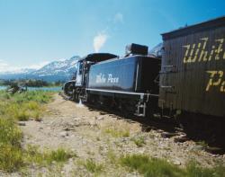
Combining British financing, American engineering, and Canadian contracting, the White Pass and Yukon was the first major civil engineering project on the continent above the 60th degree of northern latitude. Completed in 27 months using only hand tools, black powder, and regional timber, the White Pass and Yukon rises almost 2,900 feet from sea level at the port of Skagway to the White Pass summit on the U.S.-Canada border in just 20 miles, accomplishing one of the steepest climbs of any railroad in the world.
YearAdded:
Image Credit: Courtesy Wikipedia/Klanda (CC BY-SA 3.0)Image Caption: White Pass & Yukon RailroadEra_date_from: 1900
1994
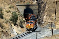
Central Pacific Railroad served as the Western terminus of America's first transcontinental railroad, passing through the formidable Sierra Nevada Mountains. In all, 15 tunnels were blasted through solid granite.
Thousands of Chinese from Kwantung Province were recruited by Central Pacific Railroad Company and became known for their diligence and hard work. In the second year of construction, nine out of ten workers on the CPRR were Chinese.
YearAdded:
Image Credit: Courtesy Flickr/Jim Bowen (CC BY 2.0)Image Caption: Central Pacific RailroadEra_date_from: 1863
1968
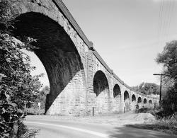
Opened in 1835, the Thomas Viaduct was the first multiple-arch, stone railroad viaduct in the United States. The viaduct is composed of eight arches each with a clear span of about 58 feet. The viaduct has an overall length of 614 feet and a height of about 60 feet above the Patapsco River. Construction of the viaduct began in August of 1833, and a ceremony marking its completion was conducted on July 4, 1835. The viaduct was constructed for the Baltimore and Ohio (B&O) Railroad and is named in honor Philip E. Thomas, who served from 1827 to 1836 as the first president of the B&O.
YearAdded:
Image Credit: Public Domain (National Park Service)Image Caption: Thomas Viaduct Railroad BridgeEra_date_from: 1835
1964
The Tehachapi Pass Railroad Line was cut through solid and decomposed granite by about 3,000 Chinese laborers using nothing more than picks, shovels, horse drawn carts, and blasting powder. This line, which rises from the San Joaquin Valley and through the Tehachapi Mountains, originally included 18 tunnels, ten bridges and several water towers to accommodate the steam locomotives. Completed in less than two years, it was part of the final line of the first railroad to connect San Francisco with Los Angeles.
YearAdded:
Image Credit: Courtesy Flickr/Doug WertmanImage Caption: Tehachapi Pass Railroad LineEra_date_from: 1876
1998
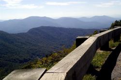
Designed to connect the Shenandoah National Park in Virginia and the Great Smokey Mountains National Park in North Carolina, the Blue Ridge Parkway was planned to provide pleasant motoring and to conserve and interpret the unique natural and cultural resources of the Southern Highlands. It was conceived also as a public works project to relieve unemployment in the Appalachian region during the Great Depression.
YearAdded:
Image Credit: Courtesy Flickr/thewebprincess (CC BY-ND 2.0) Image Caption: A stunning view from an outlook on the Blue Ridge Parkway, which is famous for its beautyEra_date_from: 1935
1999
BreezewoodHarrisburgState: PACountry: USAWebsite: http://www.asce.org/project/pennsylvania-tunpike-(old-section)/Creator: Pennsylvania Turnpike Commission
The Pennsylvania Turnpike was the first American paved highway of the automobile era in which tolls alone were expected to pay all project costs. The 160-mile roadway, which cut an east-west path from Pittsburgh to the state capital of Harrisburg, was considered a revolutionary example of transportation system design and served as a model for the Interstate Highway System.
YearAdded:
Image Credit: Courtesy Flickr/Doug Kerr (CC BY-SA 2.0)Image Caption: Pennsylvania Turnpike (Old Section)Era_date_from: 1940
1988
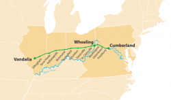
The National Road was the first interstate highway in the United States, and the first roadway to be financed with federal money. Authorized by Congress during the administration of Thomas Jefferson in 1806, the road was built over time and in sections from Cumberland, Maryland, westward through the states of Pennsylvania, Virginia (now West Virginia), Ohio, and Indiana, before terminating at the state capital of Vidalia, Illinois.
YearAdded:
Image Credit: Courtesy Wikipedia/Citynoise (CC BY-SA 2.5)Image Caption: National RoadEra_date_from: 1811
1976
Innovations
In the early 1830s, the merchants of Bristol, long dissatisfied with their communication with London, began to wonder if the new railroad technology might be a solution to their problem. The Bristol Chamber of Commerce, the Merchant Adventurers and other local industrial bodies formed a…
Read More
The North Island Main Trunk Railway permitted overland travel and development of the New Zealand hinterland. Built under challenging conditions and over difficult terrain, all cuts, fills, and tunneling were minimized by careful use of the topography and by innovative engineering.
Over…
Read More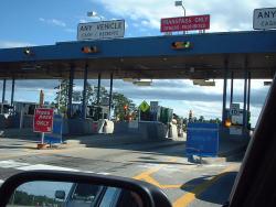
Maine's heavy snows led turnpike maintenance personnel to bring "left-handed" snow plows into prominence. By using left-handed and traditional right-handed plows in tandem, they were able to distribute snow more evenly - an important advance that has been emulated by many highway maintenance…
Read More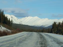
The Alaska Highway, initially called the Alaskan-Canadian (Alcan) Military Highway, provided an essential transportation link to the Yukon and Alaska during World War II. It begins at the junction with several Canadian highways in Dawson Creek, British Columbia and runs to Delta Junction, Alaska…
Read More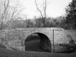
In an era when roads and canals were the most common means of overland transportation, the Allegheny Portage Railroad provided a novel alternative. The railway carried fully-loaded canal boats over the steep grades of the Allegheny Mountain. The 36-mile system rose almost 2,300 feet above sea…
Read More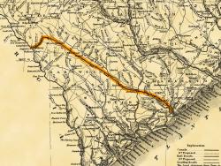
Built with a single set of tracks consisting of hardwood rails and wooden ties, and using wooden trestles to carry it over low-lying areas, the 136-mile Charleston-Hamburg Railroad was one of the longest railroads in the world when it was completed in 1833. It also became the first railroad in…
Read More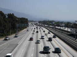
With its landscaped embankments, limited access, and depressed roadway, Arroyo Seco Parkway (now known as the Pasadena Freeway) became the prototype of the Los Angeles freeway system. Motorists enjoy a scenic drive featuring landscaped embankments lush with native chaparral. The curving…
Read More
By the 1890s, the transportation infrastructure of downtown Boston - a maze of narrow, winding streets laid out, in some cases, along Colonial cow paths - proved completely inadequate for the needs of a modern, bustling metropolis. Tremont Street, the city's main thoroughfare, was regularly…
Read More
A project that combined great engineering ambition and burgeoning civic pride, the Columbia River Highway was built at the dawn of the automobile age out of a desire to bring greater attention to the growing population and natural beauty of the Pacific Northwest. By the time of its completion in…
Read More
"This is the first Portland cement concrete street built in the United States ... Here started the better roads movement which has given our citizens from coast to coast swift and sure transportation."
- Historic marker, Bellefontaine, Ohio, celebrating the 50th anniversary of…
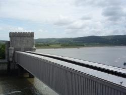
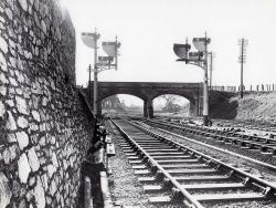
Built by Robert Stephenson to carry the Chester and Holyhead Railway across the River Conwy, this bridge was erected between 1846 and 1848. It consists of a single span 400 feet long, formed by two parallel rectangular wrought iron tubes, each weighing 1300 tons. Masonry towers were built on the…
Read More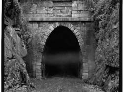
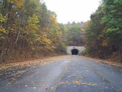
One of four single-track tunnels built by the Blue Ridge Railroad, the 4,273-foot Crozet Tunnel was constructed at a time when hand drills, pickaxes, and black powder amounted to state-of-the-art tunneling technology. At the time of its completion, it was the longest railroad tunnel in the…
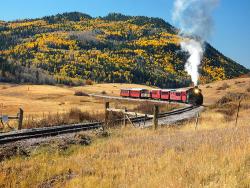
Winding over 64 miles through the majestic San Juan mountains, the narrow-gauge railway known today as the Cumbres and Toltec Scenic Railroad was built as a branch of the extensive Denver and Rio Grande Western Railroad that ran through western Colorado and most of Utah. It originally…
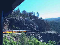
The Durango-Silverton Narrow Gauge Branch of the Denver & Rio Grande Western Railroad extends from the town of Durango to the mining camp of Silverton. Built in 1882 through one of the most rugged mountain areas of the nation, its complexity remains a testament to the role civil…
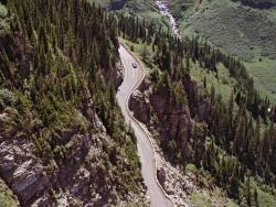
Considered one of the world's most scenic mountain drives, the two-lane Going-To-The-Sun Road through Glacier National Park was the first major road to be constructed directly over high mountain terrain, proving that roads did not need to be limited to mountain passes.
Glacier National…
Read More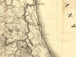
When Governor James Grant arrived in the newly acquired British colony of East Florida in 1764, he found it devoid of settlers. To increase both the population and commerce with the 13 colonies to the north, he commanded that a road be built from his provincial capital of St. Augustine to Ft.…
Read MoreThe Lake Moeris Quarry Road, in the Faiyum District of Eygpt, is the oldest road in the world of which a considerable part of its original pavement is still preserved. This road was used to help transport the heavy blocks of basalt from the quarry 43 miles southwest of Cairo to the royal…
Read More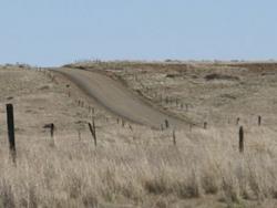
The Mullan Road was designed to facilitate the movement of troops and supplies across the Rocky Mountains between the Missouri River basin in the Great Plains and the Columbia River Basin at the Columbia Plateau during times of Indian hostilities. But because peace was reached with the Northwest…
Read More
The National Road was the first interstate highway in the United States, and the first roadway to be financed with federal money. Authorized by Congress during the administration of Thomas Jefferson in 1806, the road was built over time and in sections from Cumberland, Maryland, westward through…
Read More
The Pennsylvania Turnpike was the first American paved highway of the automobile era in which tolls alone were expected to pay all project costs. The 160-mile roadway, which cut an east-west path from Pittsburgh to the state capital of Harrisburg, was considered a revolutionary example of…
Read More