
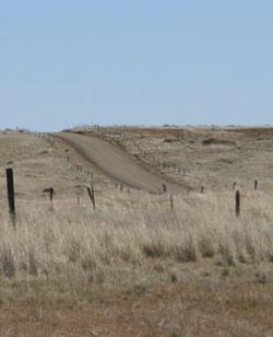
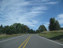
The Mullan Road was designed to facilitate the movement of troops and supplies across the Rocky Mountains between the Missouri River basin in the Great Plains and the Columbia River Basin at the Columbia Plateau during times of Indian hostilities. But because peace was reached with the Northwest Indians early on, the road was used only once (in 1860) for military means. Instead, it became a popular thoroughfare for emigrants and fortune-seekers during the Montana and Idaho gold rushes of the 1860s.
Roads & Rails
YearAdded:
Image Credit: Originally Public Domain (Author's Choice)Image Caption: Mullan RoadEra_date_from: 1862
1977
Society: ASCEMain Category: CivilSub Category: Roads & RailsEra: BCDateCreated: 2575-2137 BCLake MoerisFaiyum DistrictCountry: EgyptWebsite: http://www.asce.org/Project/Lake-Moeris-Quarry-Road/Creator: Ancient Egyptians
The Lake Moeris Quarry Road, in the Faiyum District of Eygpt, is the oldest road in the world of which a considerable part of its original pavement is still preserved. This road was used to help transport the heavy blocks of basalt from the quarry 43 miles southwest of Cairo to the royal sarcophagi and pavements for the mortuary temples at Giza just outside Cairo. The road covered the 7.5 miles from the quarry to Lake Moeris which, at that time, was 66 ft above sea level.
YearAdded:
Image Caption: Lake Moeris Quarry RoadEra_date_from: 2575
1996
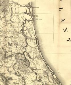
When Governor James Grant arrived in the newly acquired British colony of East Florida in 1764, he found it devoid of settlers. To increase both the population and commerce with the 13 colonies to the north, he commanded that a road be built from his provincial capital of St. Augustine to Ft. Barrington, Georgia.
YearAdded:
Image Caption: Section of a map showing King's Road in the Territory of Florida, by the United States Army Corps of Engineers, published in 1839.Era_date_from: 1775
1976
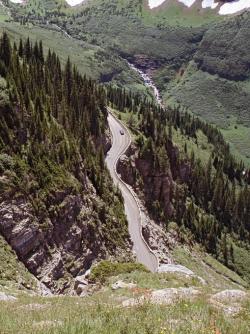
Considered one of the world's most scenic mountain drives, the two-lane Going-To-The-Sun Road through Glacier National Park was the first major road to be constructed directly over high mountain terrain, proving that roads did not need to be limited to mountain passes.
YearAdded:
Image Credit: Original Image: Flickr/Katie BradyImage Caption: Going-to-the-Sun RoadEra_date_from: 1932
1985
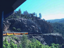
The Durango-Silverton Narrow Gauge Branch of the Denver & Rio Grande Western Railroad extends from the town of Durango to the mining camp of Silverton. Built in 1882 through one of the most rugged mountain areas of the nation, its complexity remains a testament to the role civil engineering played in the development of the western United States.
The tracks rise up the sheer, steep Animas Canyon, running along a rock ledge just wide enough to carry the train. The line is used today as a tourist attraction, carrying visitors through the picturesque San Juan Mountains.
YearAdded:
Image Caption: Durango and Silverton Narrow Gauge railway runs along the Highline.Era_date_from: 1882
1968
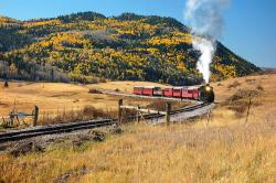
Winding over 64 miles through the majestic San Juan mountains, the narrow-gauge railway known today as the Cumbres and Toltec Scenic Railroad was built as a branch of the extensive Denver and Rio Grande Western Railroad that ran through western Colorado and most of Utah. It originally served the large number of settlers flocking to the gold and silver mines of the region.
YearAdded:
Image Credit: Courtesy Flickr/Larry Lamsa (CC BY 2.0)Image Caption: Cumbres and Toltec Scenic RailwayEra_date_from: 1880
1976
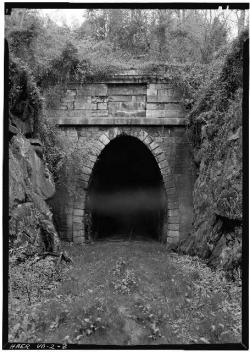
One of four single-track tunnels built by the Blue Ridge Railroad, the 4,273-foot Crozet Tunnel was constructed at a time when hand drills, pickaxes, and black powder amounted to state-of-the-art tunneling technology. At the time of its completion, it was the longest railroad tunnel in the world. Envisioned and built by Claudius Crozet, a French-born educator and civil engineer, the tunnel remains a testament to his belief in advancing rail transportation even when faced with numerous difficulties.
YearAdded:
Image Credit: Public Domain (National Park Service)Image Caption: Crozet's Blue Ridge TunnelEra_date_from: 1858
1976
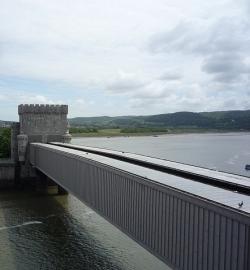
Built by Robert Stephenson to carry the Chester and Holyhead Railway across the River Conwy, this bridge was erected between 1846 and 1848. It consists of a single span 400 feet long, formed by two parallel rectangular wrought iron tubes, each weighing 1300 tons. Masonry towers were built on the abutments and topped with battlements and turrets to harmonize with the nearby Conwy Castle. The Conwy Tubular Bridge was the first railway bridge in which trains ran through the main girders. It represents a pioneering use of wrought iron for bridges.
YearAdded:
Image Credit: Original Photo: Flickr/Glenn J. MasonImage Caption: Conwy Tubular BridgeEra_date_from: 1849
2002
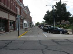
"This is the first Portland cement concrete street built in the United States ... Here started the better roads movement which has given our citizens from coast to coast swift and sure transportation."
- Historic marker, Bellefontaine, Ohio, celebrating the 50th anniversary of America's first concrete pavement, 1941
YearAdded:
Image Credit: Public Domain (Author's Choice)Image Caption: First Concrete PavementEra_date_from: 1893
1976
A project that combined great engineering ambition and burgeoning civic pride, the Columbia River Highway was built at the dawn of the automobile age out of a desire to bring greater attention to the growing population and natural beauty of the Pacific Northwest. By the time of its completion in the 1920s, the 73.8-mile highway had become a textbook example of modern highway construction and an important commercial and recreational link between Oregon's coastal Willamette Valley and the inland areas of eastern Oregon and Washington.
YearAdded:
Image Credit: Courtesy Flickr/Doug Kerr (CC BY-SA 2.0)Image Caption: Columbia River Scenic HighwayEra_date_from: 1922
1984
Innovations
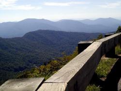
Designed to connect the Shenandoah National Park in Virginia and the Great Smokey Mountains National Park in North Carolina, the Blue Ridge Parkway was planned to provide pleasant motoring and to conserve and interpret the unique natural and cultural resources of the Southern Highlands. It was…
Read More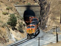
The Tehachapi Pass Railroad Line was cut through solid and decomposed granite by about 3,000 Chinese laborers using nothing more than picks, shovels, horse drawn carts, and blasting powder. This line, which rises from the San Joaquin Valley and through the Tehachapi Mountains, originally…
Read More
Opened in 1835, the Thomas Viaduct was the first multiple-arch, stone railroad viaduct in the United States. The viaduct is composed of eight arches each with a clear span of about 58 feet. The viaduct has an overall length of 614 feet and a height of about 60 feet above the Patapsco River.…
Read More
Central Pacific Railroad served as the Western terminus of America's first transcontinental railroad, passing through the formidable Sierra Nevada Mountains. In all, 15 tunnels were blasted through solid granite.
Thousands of Chinese from Kwantung Province were recruited by Central…
Read More
Combining British financing, American engineering, and Canadian contracting, the White Pass and Yukon was the first major civil engineering project on the continent above the 60th degree of northern latitude. Completed in 27 months using only hand tools, black powder, and regional timber, the…
Read More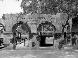
Historically, a camino real (Royal Road) is defined as a road that connects Spanish capital with Spanish capital, a distinction not shared with roads connecting ordinary Spanish or Indian villages. The term Camino Real implied that the status and privileges granted to the villas and capitals it…
Read More
El Camino Real (literally, "the royal road") is the oldest and longest historical trail in the Western Hemisphere. The transportation link has, through the centuries, been called various names, including El Camino Real de Tierra Adentro (literally, "the road to the interior" because the U.…
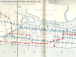
In the 19th century, New York City was a burgeoning industrial and commercial metropolis - the largest city in the United States and second largest in the world. As the city's population increased, people began to call for construction of an underground railway. Many unusual engineering…
Read More