
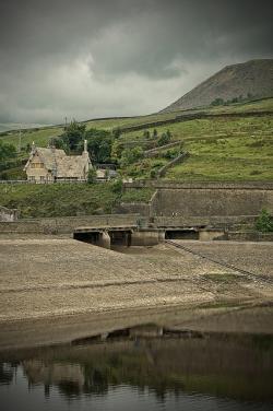
With the discoveries of South Africa's diamonds in the 1860s and gold in the 1880s, immigrants flooded into Cape Town and changed it into a major commercial center. Unfortunately, its water supply had not kept pace with the population growth. After several droughts and years of inadequate water supply, the Woodhead Tunnel was constructed between 1887 and 1891. When it failed to solve the water shortage problem, the Municipality of Cape Town determined that a dam and reservoir needed to be built.
Sandstone
YearAdded:
Image Credit: Courtesy Flickr/Tim Fields (CC BY-ND 2.0)Image Caption: Woodhead DamEra_date_from: 1897
2008
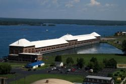
Located at the northern tip of Michigan where Lake Superior, Lake Michigan, and Lake Huron join together, the Sault Ste. Marie Hydroelectric Power Complex was built to harness the hydroelectric potential of the 20-foot falls at the headwaters of the St. Marys (sic) River, the sole outlet of Lake Superior. A century after its construction, the plant remains the largest low-head hydroelectric facility in the United States. Today, the Sault Ste. Marie plant supplies electricity to area residents, especially those in the Upper Peninsula of Michigan.
YearAdded:
Image Credit: Courtesy Flickr/Madison Berndt (CC BY 2.0)Image Caption: Sault Ste. Marie Hydroelectric ComplexEra_date_from: 1902
1983
Society: ASCEMain Category: CivilSub Category: Roads & RailsEra: BCDateCreated: 2575-2137 BCLake MoerisFaiyum DistrictCountry: EgyptWebsite: http://www.asce.org/Project/Lake-Moeris-Quarry-Road/Creator: Ancient Egyptians
The Lake Moeris Quarry Road, in the Faiyum District of Eygpt, is the oldest road in the world of which a considerable part of its original pavement is still preserved. This road was used to help transport the heavy blocks of basalt from the quarry 43 miles southwest of Cairo to the royal sarcophagi and pavements for the mortuary temples at Giza just outside Cairo. The road covered the 7.5 miles from the quarry to Lake Moeris which, at that time, was 66 ft above sea level.
YearAdded:
Image Caption: Lake Moeris Quarry RoadEra_date_from: 2575
1996
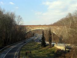
Cabin John Aqueduct, designed by Montgomery C. Meigs, conveys drinking water from Great Falls, Maryland to Washington, D.C. It was the longest stone masonry arch in the world for nearly 40 years. The segmental arch of the bridge has a span of 220 feet and a rise of only 57 feet. The main arch ring is built of cut and dressed granite. The secondary arch ring is radially-laid sandstone, of which the rest of the bridge is also constructed.
YearAdded:
Image Credit: Public Domain (Author's Choice)Image Caption: Cabin John AqueductEra_date_from: 1864
1972
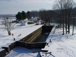
Most of the locks were 184 feet long and 36 feet wide, able to handle boats up to 160 feet long. The sandstone locks (along with wood miter gates, rock-filled timber-crib dams and bypass canals with guard gates) created a slackwater navigation system stretching over 90 miles.
YearAdded:
Image Credit: Courtesy Flickr/gb_packards (CC BY-ND 2.0)Image Caption: Muskingum River LockEra_date_from: 1837
2000
Innovations

Most of the locks were 184 feet long and 36 feet wide, able to handle boats up to 160 feet long. The sandstone locks (along with wood miter gates, rock-filled timber-crib dams and bypass canals with guard gates) created a slackwater navigation system stretching over 90 miles.
…

Cabin John Aqueduct, designed by Montgomery C. Meigs, conveys drinking water from Great Falls, Maryland to Washington, D.C. It was the longest stone masonry arch in the world for nearly 40 years. The segmental arch of the bridge has a span of 220 feet and a rise of only 57 feet. The main arch…
Read MoreThe Lake Moeris Quarry Road, in the Faiyum District of Eygpt, is the oldest road in the world of which a considerable part of its original pavement is still preserved. This road was used to help transport the heavy blocks of basalt from the quarry 43 miles southwest of Cairo to the royal…
Read More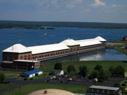
Located at the northern tip of Michigan where Lake Superior, Lake Michigan, and Lake Huron join together, the Sault Ste. Marie Hydroelectric Power Complex was built to harness the hydroelectric potential of the 20-foot falls at the headwaters of the St. Marys (sic) River, the sole outlet of…
Read More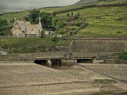
With the discoveries of South Africa's diamonds in the 1860s and gold in the 1880s, immigrants flooded into Cape Town and changed it into a major commercial center. Unfortunately, its water supply had not kept pace with the population growth. After several droughts and years of inadequate water…
Read More