
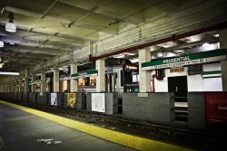
By the 1890s, the transportation infrastructure of downtown Boston - a maze of narrow, winding streets laid out, in some cases, along Colonial cow paths - proved completely inadequate for the needs of a modern, bustling metropolis. Tremont Street, the city's main thoroughfare, was regularly subject to gridlock from a convergence of foot traffic, horse-drawn conveyances, trolley lines, and electric streetcars. To rectify the problem, the Boston Transit Commission, with Howard A. Carson as chief engineer, was created in 1894 to study remedies.
Roads & Rails
YearAdded:
Image Credit: Courtesy Flickr/Kan Wu (CC BY 2.0)Image Caption: Prudential Station of the Boston SubwayEra_date_from: 1897
1978
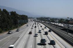
With its landscaped embankments, limited access, and depressed roadway, Arroyo Seco Parkway (now known as the Pasadena Freeway) became the prototype of the Los Angeles freeway system. Motorists enjoy a scenic drive featuring landscaped embankments lush with native chaparral. The curving alignment traverses a chain of small parks shaded by sycamores and eucalyptus and exposed views of the snow-capped San Gabriel Mountains.
YearAdded:
Image Credit: Courtesy Flickr/prayitno (CC BY 2.0) Image Caption: Arroyo Seco Parkway (also called the Pasadena Freeway) as it is seen today by thousands of commutersEra_date_from: 1940
1999
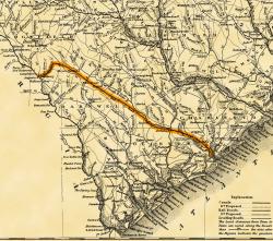
Built with a single set of tracks consisting of hardwood rails and wooden ties, and using wooden trestles to carry it over low-lying areas, the 136-mile Charleston-Hamburg Railroad was one of the longest railroads in the world when it was completed in 1833. It also became the first railroad in the United States to be powered entirely by steam, the first to carry mail under contract, and the first to provide regularly scheduled passenger service.
YearAdded:
Image Credit: The earliest general map to show the South Carolina Canal and Rail Road Company's line which began in Charleston, S.C. It was completed to Hamburg, S.C., in 1833. Its 136 miles of track were then the longest in the world. Image Caption: Charleston - Hamburg Railroad, also known as Era_date_from: 1833
1969
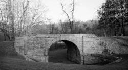
In an era when roads and canals were the most common means of overland transportation, the Allegheny Portage Railroad provided a novel alternative. The railway carried fully-loaded canal boats over the steep grades of the Allegheny Mountain. The 36-mile system rose almost 2,300 feet above sea level at its summit - the highest level to which canal boats had ever been carried. The project included ten double-tracked inclined planes, powered by steam engines. Its 900-foot Staple Bend Tunnel, cut from solid rock, was the first railroad tunnel constructed in America.
YearAdded:
Image Credit: Public Domain (National Park Service)Image Caption: The Staple Bend Tunnel, completed 1834 for the Allegheny Portage RailroadEra_date_from: 1834
1987
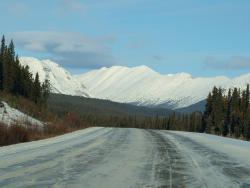
The Alaska Highway, initially called the Alaskan-Canadian (Alcan) Military Highway, provided an essential transportation link to the Yukon and Alaska during World War II. It begins at the junction with several Canadian highways in Dawson Creek, British Columbia and runs to Delta Junction, Alaska, via Whitehorse, Yukon. After the shock of Pearl Harbor, the Alaska Highway was a first step in America's defense strategy -- a vital military supply line during the war. Over ten thousand Army Engineers were rushed to the far Northwest.
YearAdded:
Image Credit: Courtesy Flickr/Bruce McKay (CC BY-SA 2.0)Image Caption: Driving on the Alaska Highway with a snowy mountain horizonEra_date_from: 1942
1995
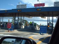
Maine's heavy snows led turnpike maintenance personnel to bring "left-handed" snow plows into prominence. By using left-handed and traditional right-handed plows in tandem, they were able to distribute snow more evenly - an important advance that has been emulated by many highway maintenance crews across the country.
YearAdded:
Image Credit: Courtesy Flickr/Doug Kerr (CC BY-SA 2.0)Image Caption: Maine TurnpikeEra_date_from: 1947
1999
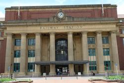
The North Island Main Trunk Railway permitted overland travel and development of the New Zealand hinterland. Built under challenging conditions and over difficult terrain, all cuts, fills, and tunneling were minimized by careful use of the topography and by innovative engineering.
Over 30 miles south of Taumarunui, the North Island Main Trunk Railway climbs 2,086 feet to the edge of the great Waimarino Plateau. But over the last seven miles, an abrupt increase in altitude of over 700 feet posed an engineering challenge that led to the design of the famed Raurimu Spiral.
YearAdded:
Image Credit: Courtesy Flickr/SibleyHunter (CC BY 2.0)Image Caption: Wellington Railway Station, part of the original North Island Main Trunk RailwayEra_date_from: 1908
1997
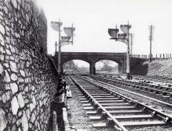
In the early 1830s, the merchants of Bristol, long dissatisfied with their communication with London, began to wonder if the new railroad technology might be a solution to their problem. The Bristol Chamber of Commerce, the Merchant Adventurers and other local industrial bodies formed a committee in 1833 to discuss the ambitious proposal of laying a railway to London. Matters progressed swiftly. Money was advanced and the search for a first-class engineer to guide the effort.
YearAdded:
Image Credit: Courtesy Flickr/Ingy The Wingy (CC BY-ND 2.0)Image Caption: Great Western Railway lower quadrant semaphore signals; 1952Era_date_from: 1838
2005
Innovations
