
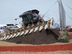
In 1941, near Palouse, Washington, Raymond A. Hanson conceived of a self-leveling mechanism for hillside combines. On the steep hills in the Pacific Northwest, leveling is necessary to save grain because of the gravity grain separation mechanism. Before the Hanson invention, manual leveling required a person to stand on the combine platform and adjust the machine to the lay of the land - a hot, tedious job. The grain-saving attributes of Hanson's invention were probably more important than the labor saving, although both were valuable.
WA
YearAdded:
Image Credit: Courtesy Wikicommons/Scoty6776 (CC BY 3.0)Image Caption: A 2011 AGCO Gleaner S77 Tritura combine demonstrates its hillside self-leveling technology
2008
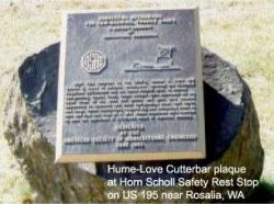
Near This Location In The 1930's James E. Love And Horace D. Hume Of Garfield, Washington, Invented The Flexible Floating Cutterbar And The Tined Pickup Reel To Harvest Low-Growing, Fragile Crops. These Devices Were Developed For The Local Crops Of Dry Peas And Lentils And Were Then Adopted Nationwide To Soybeans And Other Low-Growing Crops That Tangle And Lodge. These Mechanisms Reduced Dry Pea Harvesting Costs By 28% And Crop Loss From 50 To 10%. These Inventions Were Reported To Save The Equivalent Of 2,750,000 Acres Of Soybeans Annually.
YearAdded:
1993
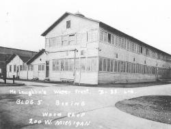
This former shipyard was the first home of the The Boeing Company, founded in 1916. Affectionately called the Red Barn, this structure was built in 1909, and became the historic birthplace of Boeing aircraft production. Starting with the Boeing Model C, all early Boeing production took place in this building. Here, the entrepreneurial spirit of William E.
YearAdded:
Image Credit: public domainImage Caption: The Boeing Red Barn taken in 1937.
2002
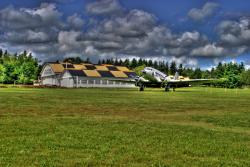
Pearson Field, named for U.S. Army Lt. Alexander Pearson Jr., a prominent early aviator who died in an airplane crash in 1925, is the oldest continuously operating airfield in the Pacific Northwest, and one of the oldest in the United States. In 1905, the field, then known as the Fort Vancouver Polo Grounds, was the landing site for a dirigible launched from the Lewis and Clark Centennial Exhibition in Portland, Ore. This marked the first crossing of the Columbia River by air, and the first time an airship was used to deliver a letter.
YearAdded:
Image Credit: Courtesy Wikicommons/John Kloepper (CC BY-SA 3.0)Image Caption: Pearson Field, in Vancouver Wa.
2012
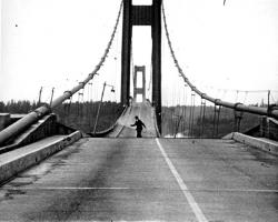
Taken together, the 1940 and 1950 Tacoma Narrows bridges mark a significant turning point in the design of long-span suspension bridges. The original 1940 structure was designed with one of the shallowest and narrowest stiffening elements of any long-span suspension bridge yet built. The structure failed dramatically in a rather moderate 42 mph windstorm on 7 November 1940, only four months after opening for traffic.
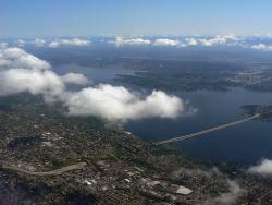
The 1.5 mile Lacey V. Murrow Bridge was the largest floating structure in the world and the first to be built of reinforced concrete when completed in 1940. The bridge consisted of typically 300-foot long pontoons floated to site and rigidly connected to form a continuous structure and incorporated a unique floating concrete draw-span to allow for passage of marine traffic. The original floating structure, constructed by Pontoon Bridge Builders, was accidentally sunk in 1990 during a major renovation effort and was replaced by 1993.
YearAdded:
Image Credit: Courtesy Wikipedia/Walter SiegmundImage Caption: The bridge and tunnel project were key in improving eastern access to Seattle, a major commercial port on the eastern rim of the Pacific Ocean. Era_date_from: 1940
2008
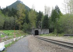
In the years following the Civil War, the land west of the Mississippi River was being settled and the Pacific Northwest explored. There remained, however, a large portion of Montana, Idaho, and Washington that contained enormous quantities of timber and minerals, but was not accessible by rail. By far the most grueling stretch was the Stevens Pass area in the Cascade Mountains.
YearAdded:
Image Credit: Courtesy Wikipedia/SeattleretroImage Caption: Railroad development in Stevens Pass made accessible a timber and mineral rich region of Montana, Idaho, and Washington.Era_date_from: 1900
1993
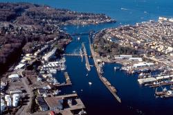
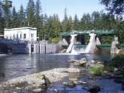
After more than 50 years of contention and debate, dredging began in 1911 on an eight-mile channel connecting Puget Sound, Seattle's gateway to the Pacific, to two inland freshwater lakes, Lake Washington and Lake Union. With the completion of the Lake Washington ship channel and Chittenden locks, coal and logs from the interior had a dedicated water route to the ocean, and the city's 4 1/2 miles of coastal harbor burgeoned into 100 miles of commercial, industrial and recreational piers and wharves.
YearAdded:
Image Credit: Courtesy Flickr/gb_packards (CC BY-ND 2.0)Image Caption: Lake Washington ship channel and Chittenden locks allowed for the transport of coal and logs and revitalized the coastal harbor.Era_date_from: 1917
1997
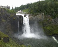
This was one of the first power facilities to demonstrate the feasibility of long distance electric power transmission. Through an elaborate switchboard at the main station, tied to similar boards at substations, a complete circuit was created to drive an electric motor 153 miles from the generator a remarkable distance at that time.
YearAdded:
Image Credit: Courtesy Flickr/Allen Sheffield (CC BY 2.0)Image Caption: Snoqualmie FallsEra_date_from: 1899
1981
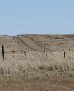
The Mullan Road was designed to facilitate the movement of troops and supplies across the Rocky Mountains between the Missouri River basin in the Great Plains and the Columbia River Basin at the Columbia Plateau during times of Indian hostilities. But because peace was reached with the Northwest Indians early on, the road was used only once (in 1860) for military means. Instead, it became a popular thoroughfare for emigrants and fortune-seekers during the Montana and Idaho gold rushes of the 1860s.
YearAdded:
Image Credit: Originally Public Domain (Author's Choice)Image Caption: Mullan RoadEra_date_from: 1862
1977
Innovations
Requests for public power in Seattle began in the late 1890s and lead to the voter approval for building the Cedar Falls Water Supply hydroelectric dam plant in 1902. The first municipally developed and owned hydroelectric plant in the United States began operation in October 1904. The facility…
Read More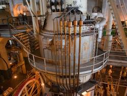
The Georgetown Steam Plant, a surprisingly complete and operable steam power plant after a career of nearly seventy-five years, was built in the early 1900s when Seattle's inexpensive hydroelectric power attracted manufacturers. Much of the power produced at this plant operated the streetcars. It… Read More
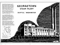
The Georgetown Steam Plant, a surprisingly complete and operable steam power plant after a career of nearly seventy-five years, was built in the early 1900s when Seattle's inexpensive hydroelectric power attracted manufacturers. Much of the power produced at this plant operated the streetcars.…
Read More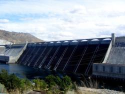
The massive Grand Coulee Dam, on the Columbia River, is the largest concrete structure in the U.S., the largest hydroelectric facility in the U.S., and the sixth-largest hydroelectric facility in the world. It provides irrigation for up to 1.1 million acres of agricultural lands and the…
Read More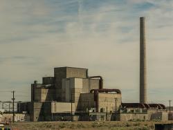
In the first nine months of operation, the B reactor produced fissionable plutonium for the world's first atomic bomb (the Trinity test on July 16, 1945), and for the atomic bomb that was dropped on Nagasaki, Japan, on August 9, 1945, killing 35,000 people. This, and similar destruction at…
Read More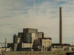
The Hanford B-Reactor was the first plutonium production reactor to be placed in operation. Its success made possible the subsequent development of atomic energy. The research work, engineering, and planning required to make the reactor operate is one of our most advanced achievements. Much of…
Read More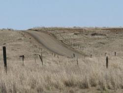
The Mullan Road was designed to facilitate the movement of troops and supplies across the Rocky Mountains between the Missouri River basin in the Great Plains and the Columbia River Basin at the Columbia Plateau during times of Indian hostilities. But because peace was reached with the Northwest…
Read More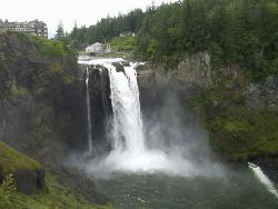
This was one of the first power facilities to demonstrate the feasibility of long distance electric power transmission. Through an elaborate switchboard at the main station, tied to similar boards at substations, a complete circuit was created to drive an electric motor 153 miles from the…
Read More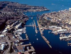
After more than 50 years of contention and debate, dredging began in 1911 on an eight-mile channel connecting Puget Sound, Seattle's gateway to the Pacific, to two inland freshwater lakes, Lake Washington and Lake Union. With the completion of the Lake Washington ship channel and Chittenden…
Read More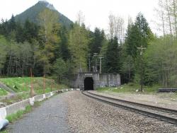
In the years following the Civil War, the land west of the Mississippi River was being settled and the Pacific Northwest explored. There remained, however, a large portion of Montana, Idaho, and Washington that contained enormous quantities of timber and minerals, but was not accessible by rail…
Read More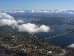
The 1.5 mile Lacey V. Murrow Bridge was the largest floating structure in the world and the first to be built of reinforced concrete when completed in 1940. The bridge consisted of typically 300-foot long pontoons floated to site and rigidly connected to form a continuous structure and…
Read More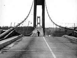
Taken together, the 1940 and 1950 Tacoma Narrows bridges mark a significant turning point in the design of long-span suspension bridges. The original 1940 structure was designed with one of the shallowest and narrowest stiffening elements of any long-span suspension bridge yet built. The…
Read More
Pearson Field, named for U.S. Army Lt. Alexander Pearson Jr., a prominent early aviator who died in an airplane crash in 1925, is the oldest continuously operating airfield in the Pacific Northwest, and one of the oldest in the United States. In 1905, the field, then known as the Fort Vancouver…
Read More
This former shipyard was the first home of the The Boeing Company, founded in 1916. Affectionately called the Red Barn, this structure was built in 1909, and became the historic birthplace of Boeing aircraft production. Starting with the Boeing Model C, all early Boeing production…
Read More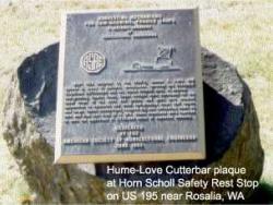
Near This Location In The 1930's James E. Love And Horace D. Hume Of Garfield, Washington, Invented The Flexible Floating Cutterbar And The Tined Pickup Reel To Harvest Low-Growing, Fragile Crops. These Devices Were Developed For The Local Crops Of Dry Peas And Lentils And Were Then…
Read More
In 1941, near Palouse, Washington, Raymond A. Hanson conceived of a self-leveling mechanism for hillside combines. On the steep hills in the Pacific Northwest, leveling is necessary to save grain because of the gravity grain separation mechanism. Before the Hanson invention, manual…
Read More