
Society
Main Category
Sub Category
Era
Date Created
Location Country
us
Coordinates
48.002778, -106.416111
Address1
Missouri River
Address2
Montana 24
City
Fort Peck
State
Country
Zip
Creator
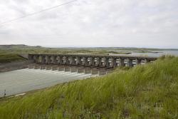
The Fort Peck Dam was a cornerstone project of the Works Progress Administration of Franklin D. Roosevelt's New Deal. It required the largest construction plant and workforce since the construction of the Panama Canal and peaked at 11,000 workers. It was the largest dam of any type in the world for over 30 years.
The record-setting, hydraulic-fill structure required the excavation of over 126 million cubic yards of earthfill, mixing the excavated soil with water and transporting the fluidized material to the dam site. Its steel sheetpile foundations, installed to control water seeping through the earth under the dam, extended to a record depth of 163 feet.
The Fort Peck Dam was more than five times larger than the largest dam in the world at the time, with its crest extending four miles.
Image Credit
Courtesy U.S. Army Corps of Engineers
Image Caption
Fort Peck Dam
