
The 50-mile Houston Ship Channel is a manmade port for ocean-going vessels, stretching from the Gulf of Mexico to Houston and Harris County, Texas.
1987

YearAdded:
Image Credit: Courtesy Flickr/Roy Luck (CC BY 2.0)Image Caption: Houston Ship ChannelEra_date_from: 1837
1987

Known as the Paper City by 1877, this site was a major industrial center with extensive paper mills, textile mills, machine shops, and a water power system that had within a few decades transformed the fields of Ireland Parish into the manufacturing city of Holyoke. A group of Boston investors created the system of dams, canals, mills, streets, and boarding houses, which was incorporated as Holyoke in 1850. Built between 1847 and 1892 according to the original plan, the dam and canals provided work for Irish immigrants and the French Canadians, Germans, and other nationalities.
YearAdded:
Image Credit: Public Domain (Produced Prior to 1/1/1923)Image Caption: Panoramic of the Holyoke Mills (The American Thread Company) on Holyoke Canal, 1909Era_date_from: 1859
1987
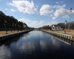
The Dismal Swamp Canal was created as a 22-mile waterway, extending from Deep Creek, Virginia to South Mills, North Carolina. The canal enabled North Carolina producers of building and agricultural products to deliver goods to the Port of Norfolk where they were transferred to ocean-going vessels.
YearAdded:
Image Credit: Photo by Edwin S. Grosvenor (CC BY 2.0)Image Caption: Dismal Swamp CanalEra_date_from: 1805
1987
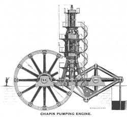
As one of the large strikes in the Lake Superior geological district, the Chapin Mine was located under a cedar swamp and unminable until it was drained by one of the largest pumping engines of the 1880s. Miners at the Chapin Mine, which began producing ore in 1880, soon tried to sink a deep shaft through 90 feet of quicksand, using enormous pumps driven by compressed air. The sand was frozen using two of the largest refrigeration compressors built, and a sectional cast-iron circular shell lined the D shaft. Mining continued for ten years using conventional pumps to dewater the lower levels.
YearAdded:
Image Credit: Public Domain; Produced prior to 1/1/1923Image Caption: Chapin Mine PumpEra_date_from: 1893
1987
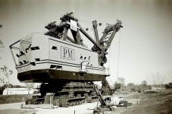
When built in 1962, this shovel was the second largest in the world. It was used for the removal of overburden in the surface mining of thin coal seams. In its lifetime, it recovered nine million tons of bituminous coal from depths of 20 to 50 feet for local electric power generation. Standing 160-feet high, weighing 5,500 tons, and moving at speeds up to two-tenths of a mile per hour, the machine stripped about a square mile each year.
YearAdded:
Image Credit: Courtesy Flickr/KellyK (CC BY-SA 2.0)Image Caption: This picture of the Big Brutus Mine Shovel does not fully capture its immensity. To create a comparison, the average person would be slightly shorter than the treads, near the bottom.Era_date_from: 1962
1987
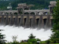
The Bonneville Dam, Columbia River Power and Navigation System consists of 55 major projects on Oregon's Columbia River and is said to be the largest hydroelectric system in the world.
The Columbia River forms part of the border between Washington and Oregon and flows inland through the only waterway that crosses the Cascade Mountains. To harness the energy of the ninth longest river in North America, engineers developed unique design and construction approaches to overcome problems caused by depth of water, current velocity, and an irregularly-shaped river bottom.
YearAdded:
Image Credit: Courtesy Flickr/Ann Larie Valentine (CC BY-SA 2.0)Image Caption: The impressive power of the Bonneville DamEra_date_from: 1938
1987

In an era when roads and canals were the most common means of overland transportation, the Allegheny Portage Railroad provided a novel alternative. The railway carried fully-loaded canal boats over the steep grades of the Allegheny Mountain. The 36-mile system rose almost 2,300 feet above sea level at its summit - the highest level to which canal boats had ever been carried. The project included ten double-tracked inclined planes, powered by steam engines. Its 900-foot Staple Bend Tunnel, cut from solid rock, was the first railroad tunnel constructed in America.
YearAdded:
Image Credit: Public Domain (National Park Service)Image Caption: The Staple Bend Tunnel, completed 1834 for the Allegheny Portage RailroadEra_date_from: 1834
1987
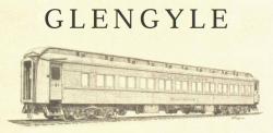
The Glengyle is the earliest known survivor of the fleet of heavyweight, all-steel sleepers built by Pullman Company. The design was introduced in 1907 as a marked improvement over the wooden version then in use. Some 10,000 were built, in various configurations, the last in 1931. The Glengyle is original in its interior and most of its components.
YearAdded:
Image Credit: Courtesy ASMEImage Caption: Pullman Sleeping Car GlengyleEra_date_from: 1911
1987
Innovations
