
On October 23rd, 1852 a notice was sent to practitioners of civil engineering in and near New York City requesting their participation in developing an association that would serve the professionals who design and construct America's built environment. Twelve men responded to this invitation, meeting on November 5 in the office of Alfred W. Craven, chief engineer of the Croton Aqueduct Department. These men became the founders of the American Society of Civil Engineers and Architects, later renamed the American Society of Civil Engineers (ASCE).
ASCE
Term Image

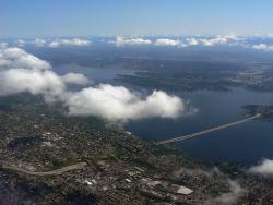
Until 1900, the Chicago River drained into Lake Michigan, along with all the sewage from the city; and the Des Plaines River west of Chicago emptied into the Illinois River, which eventually flows to the Mississippi. Chicago residents drew their drinking water from polluted areas of the lake near the mouth of the Chicago River, leading to outbreaks of typhoid and other waterborne diseases.
Amos Eaton and Stephen Van Rensselaer founded the Rensselaer School for "the application of science to the common purposes of life" in 1824. Eaton had practiced surveying as a teenager building his own compass and chain and wrote an early book on surveying. Later he studied law before becoming interested in geology and agriculture. Stephen Van Rensselaer was the seventh patroon of Rensselaerwyck a track of land comprising most of the current Rensselaer, Albany and Columbia Counties in the State of New York.
The "Land Ordinance of 1785" required that U.S. lands in the public domain be surveyed before sale, and that the surveys be made in accordance with a consistent, integrated system of lines grid-oriented to a true meridian (north-south reference line) and base line (east-west reference line), subdividing the land into approximately square parcels, called townships.
Thomas Hutchins, the first Geographer of the United States, drove his stake near East Liverpool, Ohio to mark the Point of Beginning of the Geographer's Line, the first westward base line.
YearAdded:
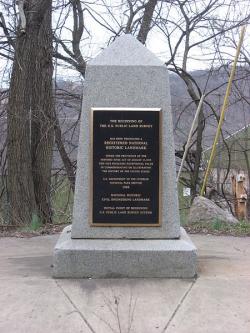
Image Credit: Courtesy Wikipedia/Nyttend Image Caption: This monument marks the site that served as the basis for the entire Public Land Survey System — the system by which most of the United States, outside of the original colonies, was surveyed.Era_date_from: 1785
1985
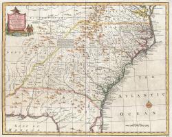
The Royal Colonial Boundary of 1665 was decreed by England's King Charles II to demarcate his American colonies. It provided a survey from the Atlantic Ocean to the Mississippi River along 36 degrees, 30 minutes north latitude. The boundary now serves to divide Virginia from North Carolina and Kentucky from Tennessee.
YearAdded:
Image Caption: Emanuel Bowen's 1747 map showing the boundary between Virginia and North Carolina.Era_date_from: 1728
1985
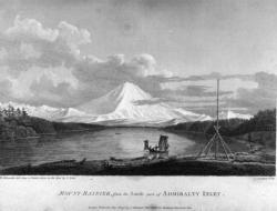
The voyage of Captain George Vancouver, 1791 -1795, was commissioned by the British Admiralty to map in detail the west coast of North America from Mexico to Alaska and to meet with Spanish authorities on the coast to enforce the terms of the Nootka Sound Convention of 1790.
YearAdded:
Image Credit: Courtesy Wikipedia/RobbotImage Caption: A view of Mount Rainier from Captain Vancouver's voyage.Era_date_from: 1791
2009
In 1915, a tropical storm dropped nearly 11 inches of rain on St. Louis in just 17 hours, causing a devastating flood. Claiming 11 lives and the homes of 1,025 families, the flood focused public and government attention onto the problems of the river.
YearAdded:
Image Credit: Courtesy Wikipedia/MillbrookyImage Caption: Today, the River Des Peres Sewage & Drainage Works provides the backbone for the 110-square-mile St. Louis drainage basin.Era_date_from: 1924
1988
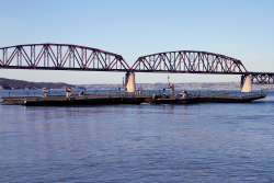
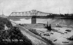
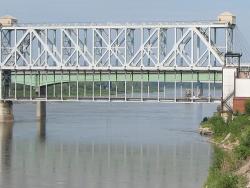
The Chamberlain is the only surviving bridge of the original five. The others were replaced as the river rose due to flood control dams put in place over time.
YearAdded:
Image Caption: Members of the South Dakota Army National Guard’s 200th Engineer Company guide a raft on the Missouri River during a river crossing operation on June 11, 2016. The Chamberlain in the background is the only surviving bridge of the five. The others were replaced as the river expanded due to flood control dams.Era_date_from: 1920
1994
The 1.5 mile Lacey V. Murrow Bridge was the largest floating structure in the world and the first to be built of reinforced concrete when completed in 1940. The bridge consisted of typically 300-foot long pontoons floated to site and rigidly connected to form a continuous structure and incorporated a unique floating concrete draw-span to allow for passage of marine traffic. The original floating structure, constructed by Pontoon Bridge Builders, was accidentally sunk in 1990 during a major renovation effort and was replaced by 1993.
YearAdded:
Image Credit: Courtesy Wikipedia/Walter SiegmundImage Caption: The bridge and tunnel project were key in improving eastern access to Seattle, a major commercial port on the eastern rim of the Pacific Ocean. Era_date_from: 1940
2008
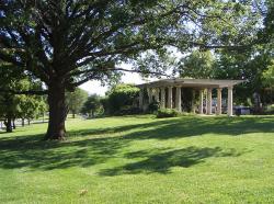
"Who in Europe, or in America for that matter, knows that Kansas City is one of the loveliest cities on earth? [...] the residential section is a masterpiece of city planning [...]; Few cities have been built with so much regard for beauty."
YearAdded:
Image Credit: Courtesy Wikipedia/CharvexImage Caption: The park system encouraged planned land use, raised real estate values, and provided incentives for quality residential developments.Era_date_from: 1915
1974
Innovations
Work began in 1887 on the high-level truss "Winner Bridge" crossing the Missouri River at Kansas City. The piers were completed in 1890, but for financial reasons the project was suspended. John Alexander Low Waddell, renowned civil engineer, prepared an alternate design for a lift bridge in…
Read More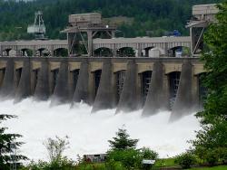
The Bonneville Dam, Columbia River Power and Navigation System consists of 55 major projects on Oregon's Columbia River and is said to be the largest hydroelectric system in the world.
The Columbia River forms part of the border between Washington and Oregon and flows inland through the…
Read More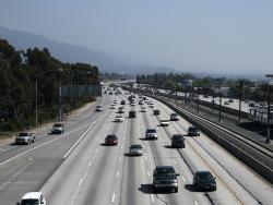
With its landscaped embankments, limited access, and depressed roadway, Arroyo Seco Parkway (now known as the Pasadena Freeway) became the prototype of the Los Angeles freeway system. Motorists enjoy a scenic drive featuring landscaped embankments lush with native chaparral. The curving…
Read More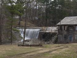
Ithamar A. Beard, an engineer of some prominence in New England, surveyed the mill brook and selected the best site for a storage dam. Contractor Simeon Cobb, knowledgeable of contemporary civil engineering practices, made major changes to the dam's original design, converting the linear dam…
Read More
The quantities of materials used in the building are staggering: 12,000 tons of structural steel; 42,000 cubic yards of concrete - consisting of 65,000 barrels of cement and 25,000 tons of sand; 360,000 feet of piling; and 10,000,000 bricks. At the time of its construction, Atlantic City…
Read More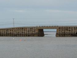
Hardy fishermen and their families have long inhabited Bailey Island, which was settled in the 1720s. Ordinarily, they did not mind crossing to the mainland in their fishing boats. But before the Bailey Island Bridge was built, during certain seasons of the year when violent storms battered the…
Read More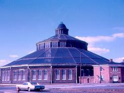
Read More"The roundhouse is an amazing survivor of an important era in American engineering and architectural history. Eric DeLony, chief of the National Park Service's Historic American Engineering Record, has called it 'the most important surviving cast-iron framed building in North…

The longest steel-arch bridge in the world for 46 years, the Bayonne Bridge continues to be celebrated today as a major aesthetic and technical achievement. The 1,675-foot bridge replaced a ferry service which until then was the only means of crossing from the Bayonne peninsula to Staten Island…
Read More
Montogomery Bell was a land developer and iron maker who purchased the Harpeth Narrows site to expand his industrial empire - which ultimately consisted of 14 iron blast furnaces throughout middle Tennessee.
The Harpeth River makes a tight bend around a steep limestone ridge, losing 17…
Read More
Belle Fourche, meaning "Beautiful Forks" in French, refers to the confluence of the Redwater and Belle Fourche Rivers. The gold rush to the Black Hills in 1876 brought many people to the area, but agriculture and livestock soon became the principal industries. Farmers and civic leaders…
Read More
The first known pumping system providing drinking and wash water in the North American colonies. The building (still standing) is dated 1761, but it was preceded by an experimental frame building dated 1754. Before the Bethlehem built its system, assigned carriers would daily haul water up the…
Read More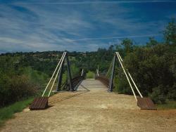
Soon after gold was discovered at Sutter's Mill near Sacramento in 1848, General John Bidwell found gold near the Middle Fork of the Feather River. His discovery brought hordes of miners to the scene and Bidwell Bar was born. The Bidwell Bar Suspension Bridge over the Feather River was one of…
Read More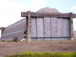
All building materials were made fire-resistant to protect against incendiary bombing. Treatment involved a vacuum process of salt impregnation. During construction, high winds caused a partial collapse of some members. The ruined materials were piled for incineration, but would not burn; so the…
Read More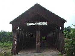
Nicholas Montgomery Powers built the bridge. It was first constructed behind the village, then taken apart and reassembled over the stream. Some residents questioned the idea of re-constructing it, but Powers was so confident of the bridge's durability that he sat on the roof when the final…
Read More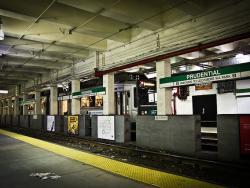
By the 1890s, the transportation infrastructure of downtown Boston - a maze of narrow, winding streets laid out, in some cases, along Colonial cow paths - proved completely inadequate for the needs of a modern, bustling metropolis. Tremont Street, the city's main thoroughfare, was regularly…
Read More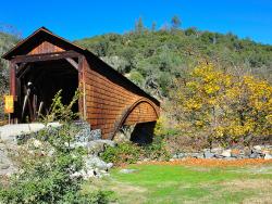
A product of the Northern California Gold Rush, the Bridgeport Covered Bridge is believed to be the longest, single-span, wooden covered bridge in the United States. Crossing the south fork of the Yuba River at a span of 233 feet, the bridge was built by the Virginia City Turnpike Company as…
Read More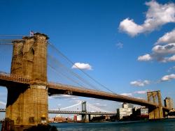
On May 24, 1883, with schools and businesses closed for the occasion, New York celebrated the opening of the Brooklyn Bridge. Also known as the Great East River Bridge, it was built over 14 years in the face of enormous difficulties. Deaths, fire in the Brooklyn caisson, and a scandal over…
Read More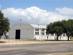
In its infancy, Hangar Nine housed Curtiss JN-4s ("Jennys") like the one Charles Lindbergh landed there when he reported for duty as a flying cadet in 1924.
As the U.S. was preparing to enter World War I, the Army raced to build an entire airfield, complete with 16 wooden hangars,…
Read More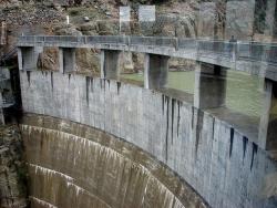
The Buffalo Bill Dam, known as the Shoshone Dam until 1946, was the first mass concrete dam in America. At nearly 325 feet high, it was also the tallest dam in the world at the time of completion.
This was one of the first arch dams in the U.S. to be designed using a mathematical method…
Read More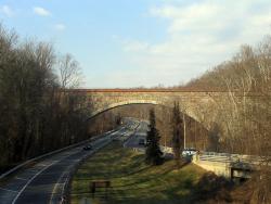
Cabin John Aqueduct, designed by Montgomery C. Meigs, conveys drinking water from Great Falls, Maryland to Washington, D.C. It was the longest stone masonry arch in the world for nearly 40 years. The segmental arch of the bridge has a span of 220 feet and a rise of only 57 feet. The main arch…
Read More