
ASCE

Term Image
Texas Commerce Bank Building
Society: ASCEMain Category: CivilSub Category: BuildingsEra: 1920-1929DateCreated: 1929JP Morgan Chase BuildingHoustonState: TXZip: 77002Country: USAWebsite: http://www.asce.org/project/texas-commerce-bank-building/Creator: Simpson, William E.

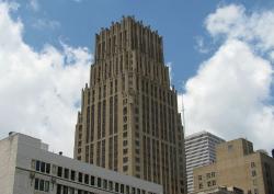
The tower was designed to rest on a continuous reinforced concrete mat, 4 feet thick, with the base of the slab 24 feet below street level.

What makes the Texas Commerce Bank Building revolutionary in the civil engineering world is not so much the building itself, but its foundation.  Initial studies for the type of foundation to be used began in the fall of 1927.  William E. Simpson, the building's chief structural engineer, suggested using a mat foundation, something new for Houston's multistory buildings.

YearAdded:
1997
Image Credit: Courtesy Wikipedia/Reagan Rothenberger Image Caption: The Texas Commerce Bank Building, now called the JP Morgan Chase Building, had a reinforced concrete mat foundation that was revolutionary at the time.Era_date_from: 1929
Stevens Pass Railroad Tunnels & Switchback System
Society: ASCEMain Category: CivilSub Category: Rail TransportationEra: 1900-1909DateCreated: 1900Stevens PassState: WAZip: 98826Country: USAWebsite: http://www.asce.org/project/stevens-pass-railroad-tunnels/Creator: Stevens, John F.

In the years following the Civil War, the land west of the Mississippi River was being settled and the Pacific Northwest explored. There remained, however, a large portion of Montana, Idaho, and Washington that contained enormous quantities of timber and minerals, but was not accessible by rail. By far the most grueling stretch was the Stevens Pass area in the Cascade Mountains.

YearAdded:
1993
Image Credit: Courtesy Wikipedia/SeattleretroImage Caption: Railroad development in Stevens Pass made accessible a timber and mineral rich region of Montana, Idaho, and Washington.Era_date_from: 1900
San Antonio River Walk & Flood Control System
Society: ASCEMain Category: CivilSub Category: Water Supply & ControlEra: 1930-1949DateCreated: 1929-1941San AntonioState: TXZip: 78205Country: USAWebsite: http://www.asce.org/Project/San-Antonio-River-Walk---Flood-Control-System/Creator: Hugman, Robert H.H., Arneson, Edward P.

San Antonio's River Walk, a catalyst for abundant commercial and tourism enterprise, is generally regarded by cities and urban planners throughout the world as a prototype for the development of urban riverfront sites. The River Walk's success, however, would not have been possible without a series of flood-control and architecture projects completed in the first half of the 20th century that relied heavily on civil-engineering expertise. 

YearAdded:
1996
Image Credit: Courtesy Flickr/Tim Pearce (CC BY 2.0) Image Caption: San antonio texas river walk 2011 riverwalkEra_date_from: 1929
Lake Washington Ship Canal & Hiram M. Chittenden Locks
Society: ASCEMain Category: CivilSub Category: Water TransportationEra: 1910-1919DateCreated: 1917Hiram M. Chittenden Locks and Carl S. English Jr. Botanical GardenZanesvilleState: WAZip: 98107Country: USAWebsite: http://www.asce.org/project/lake-washington-ship-canal---hiram-m-chittenden-locks/Creator: Chittenden, Hiram

After more than 50 years of contention and debate, dredging began in 1911 on an eight-mile channel connecting Puget Sound, Seattle's gateway to the Pacific, to two inland freshwater lakes, Lake Washington and Lake Union. With the completion of the Lake Washington ship channel and Chittenden locks, coal and logs from the interior had a dedicated water route to the ocean, and the city's 4 1/2 miles of coastal harbor burgeoned into 100 miles of commercial, industrial and recreational piers and wharves.  

YearAdded:
1997
Image Credit: Courtesy Flickr/gb_packards (CC BY-ND 2.0)Image Caption: Lake Washington ship channel and Chittenden locks allowed for the transport of coal and logs and revitalized the coastal harbor.Era_date_from: 1917
Joining of the Rails - Transcontinental Railroad
Society: ASCEMain Category: CivilSub Category: Rail TransportationEra: 1860-1869DateCreated: 1869Golden Spike RdPromontoryState: UTZip: 84307Country: USAWebsite: http://www.asce.org/project/joining-of-the-rails--transcontinental-rr/Creator: Union Pacific Railroad, Central Pacific Railroad

"May God continue the unity of our Country as this Railroad unites the two great Oceans of the world."  
- Inscription on the ceremonial Golden Spike 

The symbolic Golden Spike, staked in Promontory, Utah in 1869, marked the completion of the first transcontinental railroad, joining the Union Pacific Railroad from the East and the Central Pacific Railroad from the west. 

Image Credit: Courtesy of the National Park ServiceImage Caption: A crowd of 1,500 assembled in Promontory for the ceremony to join the rails and, symbolically, the nation.Era_date_from: 1869
Ironbridge
Society: ASCEMain Category: CivilSub Category: BridgesEra: 1750-1799DateCreated: 1779Coalbrookdale-IronbridgeZip: TF8 7ALCountry: UKWebsite: http://www.asce.org/project/iron-bridge/Creator: Darby III, Abraham

This bridge is recognized as the first iron bridge in the world. This rural region of England was an important industrial area thanks to coal deposits near the surface. In 1776 the nearest bridge that enabled people and goods to pass over the River Severn was two miles away at Buildwas. There was a ferry crossing, but the trip was difficult and dangerous especially in winter. In 1776, an Act to build a bridge to remedy this situation received Royal Assent.

Image Credit: Courtesy Wikipedia/JasonjsmithImage Caption: This bridge is recognized as the first iron bridge in the world.Era_date_from: 1779
Iron Building of the U.S. Army Arsenal
Society: ASCEMain Category: CivilSub Category: BuildingsEra: 1850-1859DateCreated: 1859US Army ArsenalWatervlietState: NYZip: 12189Country: USAWebsite: http://www.asce.org/Project/Iron-Building-of-the-U-S--Army-Arsenal/Creator: Badger, Daniel D.

The Watervliet arsenal complex originally was built to house and manufacture weapons for the War of 1812. During the Civil War, it specialized in gun cartridges and artillery carriages. The facility today is a primary site for making state-of-the-art tank cannon, howitzers, mortars, and recoilless rifles.

Image Credit: Courtesy Wikipedia/US ArmyImage Caption: The 1859 cast iron storehouse at the U.S. Army's Watervliet Arsenal is a unique example of early prefabricated construction technology.Era_date_from: 1859
International Boundary Marker #1
Society: ASCEMain Category: CivilEra: 1850-1859DateCreated: 1855El PasoState: TXCountry: USAWebsite: http://www.asce.org/project/international-boundary-marker/Creator: Emory, William

William Emory was an 1831 graduate of the U.S. Military Academy at West Point. When the Mexican War broke out, he was assigned as chief engineer officer to General Stephen Kearny, whose army traversed largely unknown territories in the West. The U.S. War Department would later print 10,000 copies of Emory's Notes of a Military Reconnaissance, which made a significant contribution to understanding the geography and topography of the Southwest.

Image Caption: The easternmost boundary marker along the Mexico–United States border, just west of the Rio Grande. The photograph is taken from the northeastern corner, in the United States. The northern side of the obelisk contains a plaque in English; the eastern side of the obelisks contains a plaque in English and Spanish; the southern side of the obelisk presumably contains a plaque in Spanish.Era_date_from: 1855
Ifugao Rice Terraces
Society: ASCEMain Category: CivilEra: BCDateCreated: BC 100BananueCountry: PhilippinesWebsite: http://www.asce.org/project/ifugao-rice-terraces/

This is the oldest and most extensive use of terraces in the world. The 20,000 hectares of terraces represent a rearrangement of the Cordillera Mountain Range from bedrock to topsoil. The engineering principles of hydrology, sustainable development, and efficient use of water resources and irrigation are all embodied in the careful design of this ancestral land management program. 

Image Credit: Courtesy Wikipedia/AgricmarketingImage Caption: Using only the simplest tools, the first inhabitants of Ifugao began the construction of 20,000 hectares of the oldest and most extensively used terraces.Era_date_from: BC 100
Hydraulics Laboratory at the University of Iowa
Society: ASCEMain Category: CivilSub Category: WaterEra: 1910-1919DateCreated: 1919Iowa CityState: IAZip: 52240Country: USAWebsite: http://www.asce.org/Project/Hydraulics-Laboratory-at-the-University-of-Iowa/Creator: University of Iowa

The Hydraulics Laboratory at The University of Iowa, renovated in 2001 and in 2003 renamed the C. Maxwell Stanley Hydraulics Laboratory, is the oldest university-based hydraulics laboratory in the U.S. that continuously has focused on research, education, and service in hydraulic engineering. Since its initial construction in 1919, the facility and staff have produced a massive amount of research that has shaped water-related constructs around the world. Its efforts have been guided by noted directors such as Floyd Nagler (1920-1933), Hunter Rouse (1944-1965), and John F.

Image Credit: Courtesy University of Iowa LibrariesImage Caption: Man sits across river from Hydraulic Laboratory, the University of Iowa, circa 1933Era_date_from: 1919
Subscribe to ASCE

Innovations

Canton Viaduct

For more than 174 years, the Canton Viaduct has stood as a dominating structure on the New England landscape. When completed in 1835, the slightly curved, granite masonry bridge - 615 feet long, 70 feet high, and 22 feet wide - carried a single track of the Boston and Providence Railroad,…

Read More
Old Cape Henry Lighthouse

The Old Cape Henry Light house was the first construction project authorized by the First Congress. Constructed by John McComb, Jr. of New York City, this project set the stage for all subsequent public works projects of the Federal Government. In addition, this specific lighthouse was a vital…

Read More
Cape Cod Canal

The idea of a canal eliminating the costly and dangerous sea trip around the Massachusetts peninsula of Cape Cod was envisioned as early as 1623 by Pilgrim leader Miles Standish. It was not until financier August Belmont became involved in 1906, however, that sufficient funds for the project…

Read More
Cape Hatteras Lighthouse

The Atlantic Ocean's northward-flowing Gulf Stream meets the southward-flowing Labrador Current at a point marked approximately by North Carolina's Outer Banks. Since the earliest days of United States commerce, shifting tides, inclement weather, treacherous shoals, and a low-lying shoreline…

Read More
Castillo de San Marcos

The fort was constructed of coquina rock. Unique to Florida, the rock consists of millions of seashells cemented together. It proved highly durable and easily absorbed the force of many cannon balls. 

The Castillo de San Marcos was the first permanent European settlement in the…

Read More
Bunker Hill Covered Bridge

In 1894, Catawba County, North Carolina commissioners asked local landowners to build and maintain an 85-foot-long bridge across Lyles Creek. The community hired Andy L. Ramsour, who served as keeper of the Horseford covered bridge over the Catawba River in Hickory, North Carolina.

Read More
Cedar Falls Water Supply

Requests for public power in Seattle began in the late 1890s and lead to the voter approval for building the Cedar Falls Water Supply hydroelectric dam plant in 1902. The first municipally developed and owned hydroelectric plant in the United States began operation in October 1904. The facility…

Read More
Chain of Rocks Water Purification Plant

Clarifying the turbid waters of the Mississippi River for use as drinking water was a formidable challenge. The Chain of Rocks Water Purification Plant provided the first application of a system of flocculation, sedimentation, and rapid sand filtration for water purification.

The system…

Read More
Carrollton Viaduct

The Carrollton Viaduct over Gwynn's Falls was the first masonry railroad viaduct constructed in the United States. This structure proved the feasibility of using a viaduct to transport railway vehicles across wide and deep valleys.

The concept for the viaduct came from international…

Read More
Cheesman Dam

The Cheesman Dam was the first major dam in the U.S. to incorporate the gravity arch, and upon completion it was the highest gravity arch stone masonry dam in the world. It is the key structure in Denver's water supply.

Three years into original construction, flooding swept away the…

Read More
Chesapeake and Delaware Canal

The Chesapeake & Delaware Canal is the only canal built in 19th-century America that still operates today as a major shipping route. Connecting the Port of Baltimore and Upper Chesapeake Bay with the mouth of the Delaware River and the Port of Philadelphia, the canal was one of the first…

Read More
Choate Bridge

The Choate Bridge of Essex County, completed in 1764, is the oldest documented two-span masonry arch bridge in the United States. Named after Colonel John Choate, who supervised the construction, the bridge is located on South Main Street and spans the Ipswich River. Originally, the bridge…

Read More
Cleveland Hopkins Airport

Constructed on 1,040 acres just 10 miles southwest of the city center, the Cleveland Hopkins Airport was the first major airport in the world to provide an integrated system of paved landing surfaces, lighted runways, and a terminal complex consisting of hangars and operating facilities.…

Read More
Colorado River Aqueduct

Stretching 242 miles from the Colorado River on the California-Arizona border to its final holding reservoir near Riverside, California, the Colorado River Aqueduct consists of more than 90 miles of tunnels, nearly 55 miles of cut-and-cover conduit, almost 30 miles of siphons, and five…

Read More
Columbia River Scenic Highway

A project that combined great engineering ambition and burgeoning civic pride, the Columbia River Highway was built at the dawn of the automobile age out of a desire to bring greater attention to the growing population and natural beauty of the Pacific Northwest. By the time of its completion in…

Read More
Columbia-Wrightsville Bridge

The total length of the Columbia-Wrightsville Bridge is 7,374 feet. Its construction required 100,000 cubic yards of concrete and 8 million pounds of steel reinforcing rods.

Consisting of 28 arches, each 185 feet long, the Columbia-Wrightsville Bridge carrying automobile traffic…

Read More
First Concrete Pavement

"This is the first Portland cement concrete street built in the United States ... Here started the better roads movement which has given our citizens from coast to coast swift and sure transportation."  
- Historic marker, Bellefontaine, Ohio, celebrating the 50th anniversary of…

Read More
Conwy Suspension Bridge

When a new road bridge was constructed alongside it, plans were made to demolish the Conwy Suspension Bridge. There was a national outcry and, since 1958, the bridge has been in the care of the National Trust and closed to vehicular traffic.

Designed by Thomas Telford in the gothic…

Read More
Conwy Tubular Bridge

Built by Robert Stephenson to carry the Chester and Holyhead Railway across the River Conwy, this bridge was erected between 1846 and 1848. It consists of a single span 400 feet long, formed by two parallel rectangular wrought iron tubes, each weighing 1300 tons. Masonry towers were built on the…

Read More
Cornish - Windsor Covered Bridge

The Cornish-Windsor Covered Bridge is the longest wooden bridge in the United States and the longest two-span, covered bridge in the world. It is also a classic example of wooden bridge-building in 19th-century America. With copious supplies of timber at hand and a generous reserve of carpentry…

Read More

We hope you enjoyed this essay.

Please support America's only magazine of the history of engineering and innovation, and the volunteers that sustain it with a donation to Invention & Technology.

Donate

Stay informed - subscribe to our newsletter.
The subscriber's email address.