
In its day, the famous Erie Canal was the world's longest canal and America's greatest engineering feat. It was the principal route for emigrants from the East and agricultural products from the West. Before construction of the canal, New York City was the nation's fifth largest seaport, behind Boston, Baltimore, Philadelphia and New Orleans. Within 15 years of its opening, New York was the busiest port in America, moving tonnages greater than Boston, Baltimore and New Orleans combined.
Water Transportation
YearAdded:
Image Credit: Courtesy Flickr/Doug Kerr (CC BY-SA 2.0)Image Caption: Erie Canal - Waterford, NYEra_date_from: 1825
1967
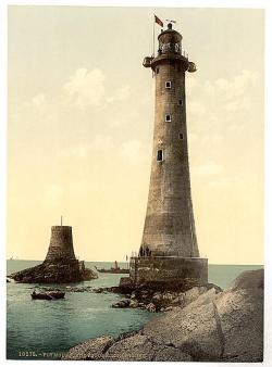
An early image of the James Douglass lighthouse, with the stump of the Smeaton-designed building beside it.
Eddystone Lighthouse is located in the English Channel, 14 miles south of Plymouth, England. The reef upon which it stands was the source of many shipwrecks... and many lighthouses, the first of which was built in 1698. The first three lighthouses were wooden, and suffered the fate of sea storms. John Smeaton built the fourth lighthouse in 1759 of Cornish granite.
YearAdded:
Image Credit: Public Domain; Produced prior to 1/1/1923Image Caption: Eddystone LighthouseEra_date_from: 1882
1991
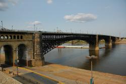
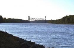
In the decade following the Civil War, the Mississippi River began to lose its standing as the primary transport artery in the Midwest. Railroads were taking over, and Chicago was rapidly becoming the center of Midwestern commerce. The Eads Bridge was the first major railroad link over the Mississippi, constructed by the city of St. Louis in an attempt to maintain its dominance as a regional commercial hub.
YearAdded:
Image Credit: Courtesy Flickr/Patrick Yodarus (CC BY-SA 2.0)Image Caption: Eads BridgeEra_date_from: 1874
1971
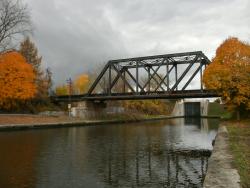
The Dismal Swamp Canal was created as a 22-mile waterway, extending from Deep Creek, Virginia to South Mills, North Carolina. The canal enabled North Carolina producers of building and agricultural products to deliver goods to the Port of Norfolk where they were transferred to ocean-going vessels.
YearAdded:
Image Credit: Photo by Edwin S. Grosvenor (CC BY 2.0)Image Caption: Dismal Swamp CanalEra_date_from: 1805
1987
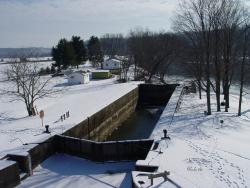
Before the Davis Island Lock & Dam were built, the flow of the Ohio River slowed to little more than a trickle during dry periods. For several months each year, the unreliable flow stranded Pittsburgh's steamboats, towboats, and barges.
The Davis Island Lock & Chanoine Dam experimental project was the first lock and dam ever constructed on the Ohio River. Its achievements also included the first rolling lock gates, the largest movable dam built in the 19th century, and the widest chamber in world history.
YearAdded:
Image Credit: Public Domain (National Park Service)Image Caption: Davis Island Lock and DamEra_date_from: 1885
1985
The Chesapeake & Delaware Canal is the only canal built in 19th-century America that still operates today as a major shipping route. Connecting the Port of Baltimore and Upper Chesapeake Bay with the mouth of the Delaware River and the Port of Philadelphia, the canal was one of the first civil engineering projects proposed in the New World and one of the most difficult to carry out. Although only 14 miles long, the canal's original cost made it one of the most expensive canals ever built in America.
YearAdded:
Image Credit: Original Image: Courtesy Flickr/Lee Cannon (CC BY-SA 2.0)Image Caption: Chesapeake and Delaware CanalEra_date_from: 1829
1985
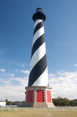
The Atlantic Ocean's northward-flowing Gulf Stream meets the southward-flowing Labrador Current at a point marked approximately by North Carolina's Outer Banks. Since the earliest days of United States commerce, shifting tides, inclement weather, treacherous shoals, and a low-lying shoreline there contributed to what soon became known as the Graveyard of the Atlantic. Warning sailors of this danger quickly became a top priority in the integrated system of navigational aids provided by the federal government to promote safe passage along the Atlantic Coast.
YearAdded:
Image Credit: Courtesy Flickr/almassengale (CC BY-ND 2.0)Image Caption: Cape Hatteras LighthouseEra_date_from: 1803
1999
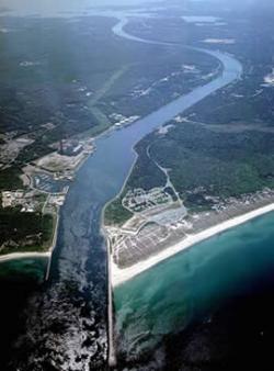
The idea of a canal eliminating the costly and dangerous sea trip around the Massachusetts peninsula of Cape Cod was envisioned as early as 1623 by Pilgrim leader Miles Standish. It was not until financier August Belmont became involved in 1906, however, that sufficient funds for the project could be raised. Belmont had been the primary backer of New York City's first subway, and chose the subway's chief engineer, William Barclay Parsons, as the canal's project director.
YearAdded:
Image Credit: Courtesy nae.usace.army.milImage Caption: Cape Cod CanalEra_date_from: 1909
1985
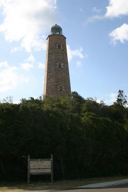
The Old Cape Henry Light house was the first construction project authorized by the First Congress. Constructed by John McComb, Jr. of New York City, this project set the stage for all subsequent public works projects of the Federal Government. In addition, this specific lighthouse was a vital navigation aid to all shipping through the Virginia Capes, thereby enhancing international and coastal trade with the Mid-Atlantic States.
YearAdded:
Image Credit: Courtesy Flickr/Matt Howry (CC BY 2.0)Image Caption: Old Cape Henry LighthouseEra_date_from: 1792
2002
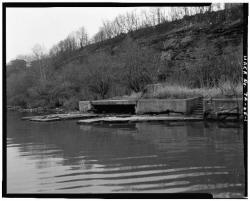
Most of the locks were 184 feet long and 36 feet wide, able to handle boats up to 160 feet long. The sandstone locks (along with wood miter gates, rock-filled timber-crib dams and bypass canals with guard gates) created a slackwater navigation system stretching over 90 miles.
YearAdded:
Image Credit: Courtesy Flickr/gb_packards (CC BY-ND 2.0)Image Caption: Muskingum River LockEra_date_from: 1837
2000
Innovations
