
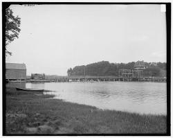
Sewall's Bridge is a singular example of an era when wooden trestle bridges carried highway traffic across New England waterways. It is the earliest pile-trestle bridge for which an authentic construction record exists, and the oldest for which builder's drawings survive. Spanning the York River, it was named for Major Samuel Sewall, Jr., the civil engineer who designed and constructed it.
1750-1799
YearAdded:
Image Credit: Public Domain (State Historical Society of Colorado)Image Caption: Sewall's BridgeEra_date_from: 1761
1986
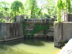
These canals and locks are a part of the first extensive system of canal and river navigation works undertaken in the United States. The idea for the canal was proposed by George Washington, when, as an engineer, surveyor and military emissary for Virginia, he saw the need for a trade route west beyond the Allegheny Mountains. In order to do create this route, it was necessary to try to tame the Potomac River which was a wild, unruly stream which only the hardiest of rivermen ever attempted.
YearAdded:
Image Credit: Courtesy Flickr/Rudi Riet (CC BY-SA 2.0)Image Caption: Potowmack Canal and LocksEra_date_from: 1799
1970
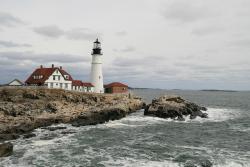
The Portland Head Light was the first lighthouse to be constructed in Maine and the first one completed and put into service by the Federal government under the Lighthouse Act of 1789, which moved to place all lighthouses under federal control. While work had begun on the lighthouse in 1787 by the State of Massachusetts which, at that time, had jurisdiction over Maine, it was completed by the Federal government. When this lighthouse was being built, Portland was the sixth largest port in the country, the closest port to Europe and had significant trade with the Caribbean.
YearAdded:
Image Credit: Courtesy Flickr/Bernt Rostad (CC BY 2.0)Image Caption: Portland Head LightEra_date_from: 1787
2002
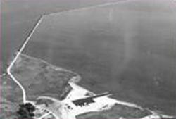
Delaware 19709New CastleState: DECountry: USAWebsite: http://www.asce.org/Project/New-Castle-Ice-Harbor/Creator: Delafield, Richard
In 1794, the Delaware legislature authorized a lottery to fund the erection of ice piers in the harbor at New Castle. The ice harbor was designed to protect anchored ships from storms and ice. At the time, New Castle served as the principal winter port for ships from the Port of Philadelphia because ice on the Delaware River posed such a serious hazard to the wooden-hulled vessels. The harbor was the first of its type on the river and the last one to be maintained as the need for them declined. It served as a model for the other four harbors constructed in the area.
YearAdded:
Image Caption: New Castle Ice HarborEra_date_from: 1794
1986
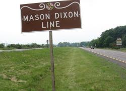
The granite milestones marking the Mason-Dixon Line bear crests from the two parties involved in the land-grant dispute, the families of William Penn and Charles Calvert (also known as Lord Baltimore).
YearAdded:
Image Credit: Original Image: Flickr/Padraic (CC BY-SA 2.0)Image Caption: Mason-Dixon LineEra_date_from: 1767
1977
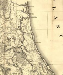
When Governor James Grant arrived in the newly acquired British colony of East Florida in 1764, he found it devoid of settlers. To increase both the population and commerce with the 13 colonies to the north, he commanded that a road be built from his provincial capital of St. Augustine to Ft. Barrington, Georgia.
YearAdded:
Image Caption: Section of a map showing King's Road in the Territory of Florida, by the United States Army Corps of Engineers, published in 1839.Era_date_from: 1775
1976
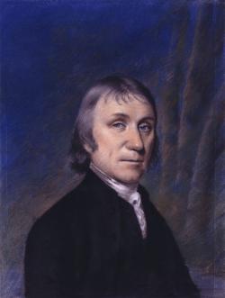
When Joseph Priestley discovered oxygen in 1774, he answered age-old questions of why and how things burn. An Englishman by birth, Priestley was deeply involved in politics and religion, as well as science. When his vocal support for the American and French revolutions made remaining in his homeland dangerous, Priestley left England in 1794 and continued his work in America until his death. His library of some 1,600 volumes and his chemical laboratory, where he first isolated carbon monoxide, were probably the best in the country at that time.
YearAdded:
Image Credit: Public Domain; Produced prior to 1/1/1923Image Caption: Joseph Priestley: Discoverer of OxygenEra_date_from: 1774
2000
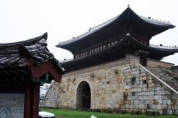
Built between 1794 and 1796 by the 22nd King of the Joseon Dynasty, Jeongio, this fortress is an outstanding example of early modern defensive works. Principally designed by Jeong Yak-Yong, it incorporated the most highly developed features of science and engineering from both the east and west.
YearAdded:
Image Credit: Courtesy Flickr/d. FUKA (CC BY-SA 2.0)Image Caption: Hwaseong FortressEra_date_from: 1796
2004
The stone was set by the joint U.S.-Spanish survey party on April 10, 1799. Made of sandstone, it is roughly two feet high and eight inches thick. On the north side of the stone is the inscription "U.S. Lat. 31, 1799." On the south side is "Dominio de S.M. Carlos IV, Lat. 31, 1799."
YearAdded:
Image Credit: Public Domain (Author's Choice)Image Caption: Ellicott's StoneEra_date_from: 1799
1968
The Choate Bridge of Essex County, completed in 1764, is the oldest documented two-span masonry arch bridge in the United States. Named after Colonel John Choate, who supervised the construction, the bridge is located on South Main Street and spans the Ipswich River. Originally, the bridge measured 80 feet 6 inches long and 20 feet 6 inches wide. In 1838 it was widened to 35 feet 6 inches on the east side in order to accommodate another lane of traffic. The west side and the parapet of the bridge, along with the inscription to Colonel Choate, remained unchanged.
YearAdded:
Image Credit: Public Domain (National Park Service)Image Caption: Choate BridgeEra_date_from: 1764
2008
Innovations
The voyage of Captain George Vancouver, 1791 -1795, was commissioned by the British Admiralty to map in detail the west coast of North America from Mexico to Alaska and to meet with Spanish authorities on the coast to enforce the terms of the Nootka Sound Convention of 1790.
Departing…
Read More
The "Land Ordinance of 1785" required that U.S. lands in the public domain be surveyed before sale, and that the surveys be made in accordance with a consistent, integrated system of lines grid-oriented to a true meridian (north-south reference line) and base line (east-west reference line),…
Read More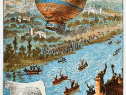
On 4 June 1783, Joseph Michel and Jacques Etienne Montgolfier captured the imagination of the world with their first balloon flight at Cordeliers Square. There were no passengers, but the Regional Council and the whole town population saw the machine go up and stay aloft at…
Read More
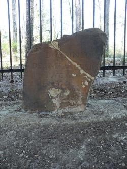
This Creative Development Which Was Responsible For The Survival Of The Cotton Industry In The United States Occurred In General Nathaniel Greene's Plantation Near Savannah 10 Miles Northeast Of This Marker. Separation By Hand Labor Of The Lint From The Seed Of The Desired Upland Variety…
Read More
ASM International - The Materials Information Society - has designated the Eli Whitney Armory an historical landmark. "On this site between 1798 and 1825, Eli Whitney built the first significant independent American armory. The development of materials processing innovations began the tradition…
Read More