
Civil

Point of Beginning, U.S. Public Lands
Society: ASCEMain Category: CivilSub Category: Boundaries & SurveysEra: 1750-1799DateCreated: 1785East LiverpoolState: OHZip: 43920Country: USAWebsite: http://www.asce.org/Project/Point-of-Beginning,-U-S--Public-Lands/Creator: Hutchins, Thomas

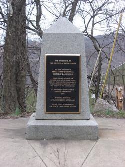
The "Land Ordinance of 1785" required that U.S. lands in the public domain be surveyed before sale, and that the surveys be made in accordance with a consistent, integrated system of lines grid-oriented to a true meridian (north-south reference line) and base line (east-west reference line), subdividing the land into approximately square parcels, called townships.  

Thomas Hutchins, the first Geographer of the United States, drove his stake near East Liverpool, Ohio to mark the Point of Beginning of the Geographer's Line, the first westward base line.

YearAdded:
1985
Image Credit: Courtesy Wikipedia/Nyttend Image Caption: This monument marks the site that served as the basis for the entire Public Land Survey System — the system by which most of the United States, outside of the original colonies, was surveyed.Era_date_from: 1785
Emanuel Bowen's 1747 map showing the boundary between Virginia and North Carolina.
Society: ASCEMain Category: CivilSub Category: Boundaries & SurveysEra: 1700-1749DateCreated: 1728-1821MiddlesboroState: KYCountry: USAWebsite: http://www.asce.org/Project/Royal-Colonial-Boundary-of-1665/Creator: Charles II

The Royal Colonial Boundary of 1665 was decreed by England's King Charles II to demarcate his American colonies. It provided a survey from the Atlantic Ocean to the Mississippi River along 36 degrees, 30 minutes north latitude. The boundary now serves to divide Virginia from North Carolina and Kentucky from Tennessee. 

YearAdded:
1985
Image Caption: Emanuel Bowen's 1747 map showing the boundary between Virginia and North Carolina.Era_date_from: 1728
Vancouver's Mapping of the West Coast of North America
Society: ASCEMain Category: CivilSub Category: Boundaries & SurveysEra: 1750-1799DateCreated: 1791-1795West Coast of North AmericaN/ACountry: USAWebsite: https://www.asce.org/project/vancouver-s-mapping-of-the-west-coast-of-n-a-/Creator: Vancouver, George

The voyage of Captain George Vancouver, 1791 -1795, was commissioned by the British Admiralty to map in detail the west coast of North America from Mexico to Alaska and to meet with Spanish authorities on the coast to enforce the terms of the Nootka Sound Convention of 1790. 

YearAdded:
2009
Image Credit: Courtesy Wikipedia/RobbotImage Caption: A view of Mount Rainier from Captain Vancouver's voyage.Era_date_from: 1791
River des Peres Sewage & Drainage Works
Society: ASCEMain Category: CivilSub Category: BridgesEra: 1920-1929DateCreated: 1924-1921St. LouisState: MOZip: 63109Country: USAWebsite: http://www.asce.org/Project/River-des-Peres-Sewage---Drainage-Works/Creator: Horner, W.W.

In 1915, a tropical storm dropped nearly 11 inches of rain on St. Louis in just 17 hours, causing a devastating flood. Claiming 11 lives and the homes of 1,025 families, the flood focused public and government attention onto the problems of the river. 

YearAdded:
1988
Image Credit: Courtesy Wikipedia/MillbrookyImage Caption: Today, the River Des Peres Sewage & Drainage Works provides the backbone for the 110-square-mile St. Louis drainage basin.Era_date_from: 1924
Missouri River Bridge
Society: ASCEMain Category: CivilSub Category: BridgesEra: 1920-1929DateCreated: 1920-1927ChamberlainState: SDZip: 57325Country: USAWebsite: http://www.asce.org/Project/Missouri-River-Bridges/Creator: Kirkham, John Edward

The Chamberlain is the only surviving bridge of the original five. The others were replaced as the river rose due to flood control dams put in place over time.

YearAdded:
1994
Image Caption: Members of the South Dakota Army National Guard’s 200th Engineer Company guide a raft on the Missouri River during a river crossing operation on June 11, 2016. The Chamberlain in the background is the only surviving bridge of the five. The others were replaced as the river expanded due to flood control dams.Era_date_from: 1920
Lacey V. Murrow Bridge and Mount Baker Ridge Tunnels
Society: ASCEMain Category: CivilSub Category: BridgesEra: 1940-1949DateCreated: 1940King County State: WAZip: 98040Country: USAWebsite: http://www.asce.org/Project/Lacey-V--Murrow-Bridge-and-Mount-Baker-Ridge-Tunnels/Creator: Murrow, Lacey V., Hadley, Homer

The 1.5 mile Lacey V. Murrow Bridge was the largest floating structure in the world and the first to be built of reinforced concrete when completed in 1940.  The bridge consisted of typically 300-foot long pontoons floated to site and rigidly connected to form a continuous structure and incorporated a unique floating concrete draw-span to allow for passage of marine traffic.  The original floating structure, constructed by Pontoon Bridge Builders, was accidentally sunk in 1990 during a major renovation effort and was replaced by 1993.

YearAdded:
2008
Image Credit: Courtesy Wikipedia/Walter SiegmundImage Caption: The bridge and tunnel project were key in improving eastern access to Seattle, a major commercial port on the eastern rim of the Pacific Ocean. Era_date_from: 1940
Kansas City Park and Boulevard System
Society: ASCEMain Category: CivilSub Category: BuildingsEra: 1910-1919DateCreated: 1915Kansas CityState: MIZip: 64106Country: USAWebsite: http://www.asce.org/Project/Kansas-City-Park-and-Boulevard-System/Creator: Kessler, George

"Who in Europe, or in America for that matter, knows that Kansas City is one of the loveliest cities on earth? [...] the residential section is a masterpiece of city planning [...]; Few cities have been built with so much regard for beauty."  

YearAdded:
1974
Image Credit: Courtesy Wikipedia/CharvexImage Caption: The park system encouraged planned land use, raised real estate values, and provided incentives for quality residential developments.Era_date_from: 1915
Texas Commerce Bank Building
Society: ASCEMain Category: CivilSub Category: BuildingsEra: 1920-1929DateCreated: 1929JP Morgan Chase BuildingHoustonState: TXZip: 77002Country: USAWebsite: http://www.asce.org/project/texas-commerce-bank-building/Creator: Simpson, William E.

The tower was designed to rest on a continuous reinforced concrete mat, 4 feet thick, with the base of the slab 24 feet below street level.

What makes the Texas Commerce Bank Building revolutionary in the civil engineering world is not so much the building itself, but its foundation.  Initial studies for the type of foundation to be used began in the fall of 1927.  William E. Simpson, the building's chief structural engineer, suggested using a mat foundation, something new for Houston's multistory buildings.

YearAdded:
1997
Image Credit: Courtesy Wikipedia/Reagan Rothenberger Image Caption: The Texas Commerce Bank Building, now called the JP Morgan Chase Building, had a reinforced concrete mat foundation that was revolutionary at the time.Era_date_from: 1929
Stevens Pass Railroad Tunnels & Switchback System
Society: ASCEMain Category: CivilSub Category: Rail TransportationEra: 1900-1909DateCreated: 1900Stevens PassState: WAZip: 98826Country: USAWebsite: http://www.asce.org/project/stevens-pass-railroad-tunnels/Creator: Stevens, John F.

In the years following the Civil War, the land west of the Mississippi River was being settled and the Pacific Northwest explored. There remained, however, a large portion of Montana, Idaho, and Washington that contained enormous quantities of timber and minerals, but was not accessible by rail. By far the most grueling stretch was the Stevens Pass area in the Cascade Mountains.

YearAdded:
1993
Image Credit: Courtesy Wikipedia/SeattleretroImage Caption: Railroad development in Stevens Pass made accessible a timber and mineral rich region of Montana, Idaho, and Washington.Era_date_from: 1900
San Antonio River Walk & Flood Control System
Society: ASCEMain Category: CivilSub Category: Water Supply & ControlEra: 1930-1949DateCreated: 1929-1941San AntonioState: TXZip: 78205Country: USAWebsite: http://www.asce.org/Project/San-Antonio-River-Walk---Flood-Control-System/Creator: Hugman, Robert H.H., Arneson, Edward P.

San Antonio's River Walk, a catalyst for abundant commercial and tourism enterprise, is generally regarded by cities and urban planners throughout the world as a prototype for the development of urban riverfront sites. The River Walk's success, however, would not have been possible without a series of flood-control and architecture projects completed in the first half of the 20th century that relied heavily on civil-engineering expertise. 

YearAdded:
1996
Image Credit: Courtesy Flickr/Tim Pearce (CC BY 2.0) Image Caption: San antonio texas river walk 2011 riverwalkEra_date_from: 1929
Subscribe to Civil

Innovations

Cape Cod Canal

The idea of a canal eliminating the costly and dangerous sea trip around the Massachusetts peninsula of Cape Cod was envisioned as early as 1623 by Pilgrim leader Miles Standish. It was not until financier August Belmont became involved in 1906, however, that sufficient funds for the project…

Read More
Cape Hatteras Lighthouse

The Atlantic Ocean's northward-flowing Gulf Stream meets the southward-flowing Labrador Current at a point marked approximately by North Carolina's Outer Banks. Since the earliest days of United States commerce, shifting tides, inclement weather, treacherous shoals, and a low-lying shoreline…

Read More
Castillo de San Marcos

The fort was constructed of coquina rock. Unique to Florida, the rock consists of millions of seashells cemented together. It proved highly durable and easily absorbed the force of many cannon balls. 

The Castillo de San Marcos was the first permanent European settlement in the…

Read More
Bunker Hill Covered Bridge

In 1894, Catawba County, North Carolina commissioners asked local landowners to build and maintain an 85-foot-long bridge across Lyles Creek. The community hired Andy L. Ramsour, who served as keeper of the Horseford covered bridge over the Catawba River in Hickory, North Carolina.

Read More
Cedar Falls Water Supply

Requests for public power in Seattle began in the late 1890s and lead to the voter approval for building the Cedar Falls Water Supply hydroelectric dam plant in 1902. The first municipally developed and owned hydroelectric plant in the United States began operation in October 1904. The facility…

Read More
Chain of Rocks Water Purification Plant

Clarifying the turbid waters of the Mississippi River for use as drinking water was a formidable challenge. The Chain of Rocks Water Purification Plant provided the first application of a system of flocculation, sedimentation, and rapid sand filtration for water purification.

The system…

Read More
Carrollton Viaduct

The Carrollton Viaduct over Gwynn's Falls was the first masonry railroad viaduct constructed in the United States. This structure proved the feasibility of using a viaduct to transport railway vehicles across wide and deep valleys.

The concept for the viaduct came from international…

Read More
Cheesman Dam

The Cheesman Dam was the first major dam in the U.S. to incorporate the gravity arch, and upon completion it was the highest gravity arch stone masonry dam in the world. It is the key structure in Denver's water supply.

Three years into original construction, flooding swept away the…

Read More
Chesapeake and Delaware Canal

The Chesapeake & Delaware Canal is the only canal built in 19th-century America that still operates today as a major shipping route. Connecting the Port of Baltimore and Upper Chesapeake Bay with the mouth of the Delaware River and the Port of Philadelphia, the canal was one of the first…

Read More
Choate Bridge

The Choate Bridge of Essex County, completed in 1764, is the oldest documented two-span masonry arch bridge in the United States. Named after Colonel John Choate, who supervised the construction, the bridge is located on South Main Street and spans the Ipswich River. Originally, the bridge…

Read More
Colorado River Aqueduct

Stretching 242 miles from the Colorado River on the California-Arizona border to its final holding reservoir near Riverside, California, the Colorado River Aqueduct consists of more than 90 miles of tunnels, nearly 55 miles of cut-and-cover conduit, almost 30 miles of siphons, and five…

Read More
Columbia River Scenic Highway

A project that combined great engineering ambition and burgeoning civic pride, the Columbia River Highway was built at the dawn of the automobile age out of a desire to bring greater attention to the growing population and natural beauty of the Pacific Northwest. By the time of its completion in…

Read More
Columbia-Wrightsville Bridge

The total length of the Columbia-Wrightsville Bridge is 7,374 feet. Its construction required 100,000 cubic yards of concrete and 8 million pounds of steel reinforcing rods.

Consisting of 28 arches, each 185 feet long, the Columbia-Wrightsville Bridge carrying automobile traffic…

Read More
First Concrete Pavement

"This is the first Portland cement concrete street built in the United States ... Here started the better roads movement which has given our citizens from coast to coast swift and sure transportation."  
- Historic marker, Bellefontaine, Ohio, celebrating the 50th anniversary of…

Read More
Conwy Suspension Bridge

When a new road bridge was constructed alongside it, plans were made to demolish the Conwy Suspension Bridge. There was a national outcry and, since 1958, the bridge has been in the care of the National Trust and closed to vehicular traffic.

Designed by Thomas Telford in the gothic…

Read More
Conwy Tubular Bridge

Built by Robert Stephenson to carry the Chester and Holyhead Railway across the River Conwy, this bridge was erected between 1846 and 1848. It consists of a single span 400 feet long, formed by two parallel rectangular wrought iron tubes, each weighing 1300 tons. Masonry towers were built on the…

Read More
Cooper Steam Traction Engine Collection

These engines, built by Cooper & Co., of Mount Vernon are among the oldest surviving agricultural steam engines to show the evolution from the portable, skid-mounted engine (ca. 1860) to the horse-drawn engine (1875), through the self-propelled but horse-guided engine (1875) and finally to…

Read More
Cornish - Windsor Covered Bridge

The Cornish-Windsor Covered Bridge is the longest wooden bridge in the United States and the longest two-span, covered bridge in the world. It is also a classic example of wooden bridge-building in 19th-century America. With copious supplies of timber at hand and a generous reserve of carpentry…

Read More
Cortland Street Drawbridge

In 1899, engineers from the City of Chicago's Division of Bridges and Viaducts performed a survey of moveable bridge design in the U.S. and Europe. Their study led to the conclusion that the unusual trunnion bascule design would best meet their needs.

The Cortland Street Drawbridge…

Read More
Craigellachie Bridge

This elegant cast iron arch bridge designed by Scotland's famous Thomas Telford was built from 1812 to 1814.  It is the earliest surviving example of a portable lattice-braced standard type that Telford developed for use at wide and deep water crossing sites unsuitable for masonry spans.  …

Read More

We hope you enjoyed this essay.

Please support America's only magazine of the history of engineering and innovation, and the volunteers that sustain it with a donation to Invention & Technology.

Donate

Stay informed - subscribe to our newsletter.
The subscriber's email address.