
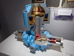
The HP-35 was the first handheld calculator to perform transcendental functions (such as trigonometric, logarithmic and exponential functions). Most contemporary calculators could only perform the four basic operations – addition, subtraction, multiplication, and division. The HP-35 and subsequent models have replaced the slide rule, used by generations of engineers and scientists.
USA

YearAdded:
Image Credit: Courtesy WikipediaImage Caption: The HP-35 was the innovative culmination of mechanical design, state-of-the-art technology, algorithm development and application; all unique at the time.Era_date_from: 1972
2009
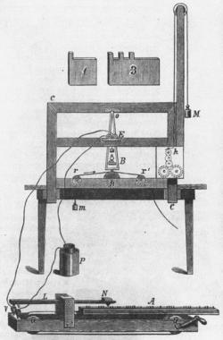
In January 1838, Samuel F. B. Morse and Alfred Vail first demonstrated publicly crucial elements of their telegraph system, using instruments that Vail had constructed during the previous months. Electrical pulses, transmitted through two miles of wire, caused an electromagnet to ink dots and dashes (grouped to represent letters and words) on a strip of paper. Commercialization began in 1844 when funding became available.
A ministerial student, a professor of fine arts, and a prominent industrialist...
YearAdded:
Image Credit: Courtesy WikipediaImage Caption: The original Samuel Morse telegraphEra_date_from: 1838
1988
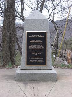
The "Land Ordinance of 1785" required that U.S. lands in the public domain be surveyed before sale, and that the surveys be made in accordance with a consistent, integrated system of lines grid-oriented to a true meridian (north-south reference line) and base line (east-west reference line), subdividing the land into approximately square parcels, called townships.
Thomas Hutchins, the first Geographer of the United States, drove his stake near East Liverpool, Ohio to mark the Point of Beginning of the Geographer's Line, the first westward base line.
YearAdded:
Image Credit: Courtesy Wikipedia/Nyttend Image Caption: This monument marks the site that served as the basis for the entire Public Land Survey System — the system by which most of the United States, outside of the original colonies, was surveyed.Era_date_from: 1785
1985
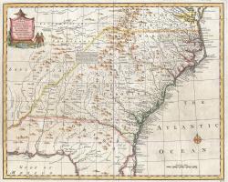
The Royal Colonial Boundary of 1665 was decreed by England's King Charles II to demarcate his American colonies. It provided a survey from the Atlantic Ocean to the Mississippi River along 36 degrees, 30 minutes north latitude. The boundary now serves to divide Virginia from North Carolina and Kentucky from Tennessee.
YearAdded:
Image Caption: Emanuel Bowen's 1747 map showing the boundary between Virginia and North Carolina.Era_date_from: 1728
1985
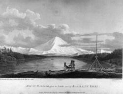
The voyage of Captain George Vancouver, 1791 -1795, was commissioned by the British Admiralty to map in detail the west coast of North America from Mexico to Alaska and to meet with Spanish authorities on the coast to enforce the terms of the Nootka Sound Convention of 1790.
YearAdded:
Image Credit: Courtesy Wikipedia/RobbotImage Caption: A view of Mount Rainier from Captain Vancouver's voyage.Era_date_from: 1791
2009
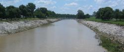
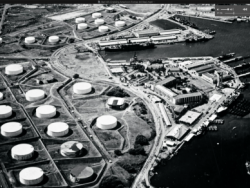
In 1915, a tropical storm dropped nearly 11 inches of rain on St. Louis in just 17 hours, causing a devastating flood. Claiming 11 lives and the homes of 1,025 families, the flood focused public and government attention onto the problems of the river.
YearAdded:
Image Credit: Courtesy Wikipedia/MillbrookyImage Caption: Today, the River Des Peres Sewage & Drainage Works provides the backbone for the 110-square-mile St. Louis drainage basin.Era_date_from: 1924
1988
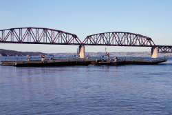
The Chamberlain is the only surviving bridge of the original five. The others were replaced as the river rose due to flood control dams put in place over time.
YearAdded:
Image Caption: Members of the South Dakota Army National Guard’s 200th Engineer Company guide a raft on the Missouri River during a river crossing operation on June 11, 2016. The Chamberlain in the background is the only surviving bridge of the five. The others were replaced as the river expanded due to flood control dams.Era_date_from: 1920
1994
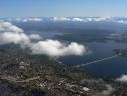
The 1.5 mile Lacey V. Murrow Bridge was the largest floating structure in the world and the first to be built of reinforced concrete when completed in 1940. The bridge consisted of typically 300-foot long pontoons floated to site and rigidly connected to form a continuous structure and incorporated a unique floating concrete draw-span to allow for passage of marine traffic. The original floating structure, constructed by Pontoon Bridge Builders, was accidentally sunk in 1990 during a major renovation effort and was replaced by 1993.
YearAdded:
Image Credit: Courtesy Wikipedia/Walter SiegmundImage Caption: The bridge and tunnel project were key in improving eastern access to Seattle, a major commercial port on the eastern rim of the Pacific Ocean. Era_date_from: 1940
2008
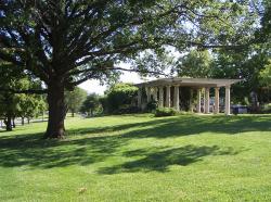
"Who in Europe, or in America for that matter, knows that Kansas City is one of the loveliest cities on earth? [...] the residential section is a masterpiece of city planning [...]; Few cities have been built with so much regard for beauty."
YearAdded:
Image Credit: Courtesy Wikipedia/CharvexImage Caption: The park system encouraged planned land use, raised real estate values, and provided incentives for quality residential developments.Era_date_from: 1915
1974
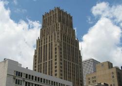
The tower was designed to rest on a continuous reinforced concrete mat, 4 feet thick, with the base of the slab 24 feet below street level.
What makes the Texas Commerce Bank Building revolutionary in the civil engineering world is not so much the building itself, but its foundation. Initial studies for the type of foundation to be used began in the fall of 1927. William E. Simpson, the building's chief structural engineer, suggested using a mat foundation, something new for Houston's multistory buildings.
YearAdded:
Image Credit: Courtesy Wikipedia/Reagan Rothenberger Image Caption: The Texas Commerce Bank Building, now called the JP Morgan Chase Building, had a reinforced concrete mat foundation that was revolutionary at the time.Era_date_from: 1929
1997
Innovations
Used to lift molten iron to molds where it was cast into pipe, jib cranes were the sole means of conveyance in the pit-casting process. When pit casting was replaced by centrifugal casting in the 1920s, many pits were filled and the cranes were used to produce cast iron fittings or general…
Read More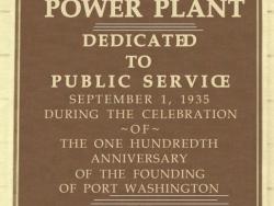
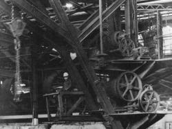
The Port Washington Power Plant of the Wisconsin Electric Company was the most thermally efficient steam power plant in the world for many years following its opening in 1935. Its design reflected the cumulative experience of the utility's engineers in burning pulverized coal at the Oneida…
Read More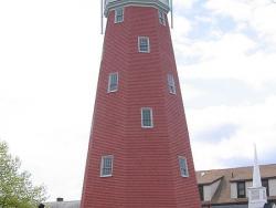
The Portland Observatory was built in 1807 by Captain Lemuel Moody to serve as a communication station for Portland Harbor. Portland Observatory was one of the earliest marine signal stations in the United States, and it is the last known to survive. The Observatory's location on Munjoy Hill…
Read More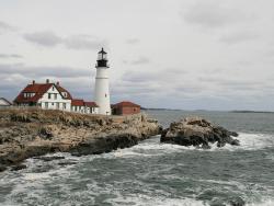
The Portland Head Light was the first lighthouse to be constructed in Maine and the first one completed and put into service by the Federal government under the Lighthouse Act of 1789, which moved to place all lighthouses under federal control. While work had begun on the lighthouse in 1787 by…
Read More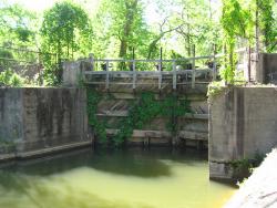
These canals and locks are a part of the first extensive system of canal and river navigation works undertaken in the United States. The idea for the canal was proposed by George Washington, when, as an engineer, surveyor and military emissary for Virginia, he saw the need for a trade route west…
Read More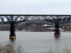
A bridge across the Hudson at or near Poughkeepsie was planned starting in the early 1870s to primarily carry coal from the coalfields of northeastern Pennsylvania to New England. At the time there were no bridges between Albany and New York Harbor. Horatio Allen, soon to be President of the…
Read More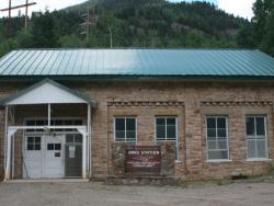
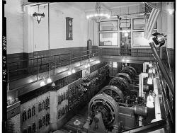
Read More"Electricity produced here in the spring of 1891 was transmitted 2.6 miles over rugged and at times inaccessible terrain to provide power for operating the motor-driven mill at the Gold King Mine. This pioneering demonstration of the practical value of transmitting electrical power…
Steam and the inexpensive electricity it could produce brought about dramatic technical growth in the United States. Developed during the last century, reliable and efficient steam engines were the forerunners of today's massive generating facilities. A rare survivor of the period, the Pratt…
Read More
In fulfilling a contract for 25,000 U.S. Army rifles (Model 1841) and a like quantity for the British government, Robbins and Lawrence were the first to achieve interchangeability of parts on a fully practical level, contributing greatly to all subsequent mass production of machine products. This… Read More
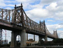
When opened in 1909, the Queensboro Bridge had the two longest steel cantilever spans in the world - 1,182 feet from Manhattan to Blackwell's Island and 984 feet from Blackwell's Island to Queens. These would remain the world's longest cantilever spans until the completion of the Quebec Bridge…
Read More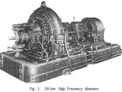
"The Alexanderson radio alternator was a high-power, radio-frequency source which provided reliable transoceanic radiotelegraph communication during and after World War I. Ernst F.W. Alexanderson (1878-1975), a General Electric engineer, designed radio alternators with a frequency range to 100 kHz… Read More
This mechanism allowed the manual closing of a well, saved lives and prevented surface oil accumulation at drilling sites, quickly becoming an industry standard. In the early days of oilfield operations, there was no way to control the underground pressures encountered during drilling. When an oil… Read More
Conceived in the early years of World War II as a plan to bury four fuel containers horizontally in a hillside at the U.S. Navy facility at Pearl Harbor, Hawaii, the Red Hill Underground Fuel Storage Facility ultimately encompassed the design and construction of 20 vertical storage tanks - each…
Read More
The first authenticated discovery of gold in the U.S. occurred on the Cabarrus County farm of John Reed in 1799, sparking the nation's first gold rush. During its peak years, more than a million dollars of gold was recovered a year, making North Carolina a leader in gold production until 1848.…
Read More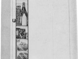
This collection includes many examples of advances in mechanical refrigeration for residential and commercial applications, dating from about 1890 to 1960. Such devices dramatically improved food storage safety and convenience and set high standards for mechanical reliability. The RRM collection…
Read More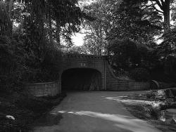
Alvord Lake Bridge, along with many of Ernest Ransome's reinforced concrete buildings, survived the 1906 San Francisco earthquake and several subsequent tremblers with no damage. Built in 1889 by Ernest L Ransome of New York, this reinforced concrete arch bridge in San Francisco's Golden Gate…
Read More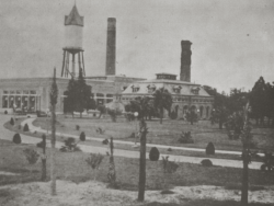
Installed alongside an Epping Carpenter pump that was later scrapped, this water pump was built by Allis-Chalmers, which for many years had Edwin Reynolds as its chief engineer. Driven by a Corliss steam engine, these large city water pumps were installed in Jacksonville's water supply…
Read More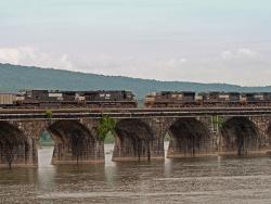
The third bridge built on the same site to carry railroad tracks across the Susquehanna River just north of Harrisburg, Pennsylvania, the Rockville Stone Arch Bridge, at 3,820 feet long and 52 feet wide, is believed to be the longest and widest stone-arch railroad bridge in the world. A central…
Read More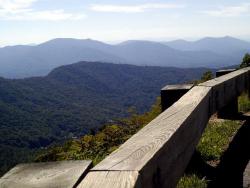
Designed to connect the Shenandoah National Park in Virginia and the Great Smokey Mountains National Park in North Carolina, the Blue Ridge Parkway was planned to provide pleasant motoring and to conserve and interpret the unique natural and cultural resources of the Southern Highlands. It was…
Read More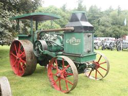
Beginning with the blacksmith shop of German immigrant Meinrad Rumely (1823-1904), this successive family of firms invented and produced a line of agricultural equipment that played a vital role in the evolution of farming based on the muscle of humans and animals to one based on the power of…
Read More