
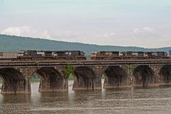
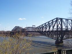
The third bridge built on the same site to carry railroad tracks across the Susquehanna River just north of Harrisburg, Pennsylvania, the Rockville Stone Arch Bridge, at 3,820 feet long and 52 feet wide, is believed to be the longest and widest stone-arch railroad bridge in the world. A central link in rail travel between New York City and Pittsburgh, the Rockville Stone Arch Bridge accommodates four lines of railroad tracks, today serving both the Norfolk Southern and Amtrak lines.
ASCE
Term Image

YearAdded:
Image Credit: Courtesy Flickr/John Mueller (CC BY 2.0)Image Caption: Rockville Stone Arch BridgeEra_date_from: 1902
1979
Alvord Lake Bridge, along with many of Ernest Ransome's reinforced concrete buildings, survived the 1906 San Francisco earthquake and several subsequent tremblers with no damage. Built in 1889 by Ernest L Ransome of New York, this reinforced concrete arch bridge in San Francisco's Golden Gate Park is believed to be the oldest concrete bridge in the United States that used steel reinforcing bars to improve the behavior of the concrete. The reinforcement consists of a series of square cold-twisted steel reinforcing bars, an invention of Ransome.
YearAdded:
Image Credit: Public Domain (National Park Service)Image Caption: Alvord Lake BridgeEra_date_from: 1889
1969
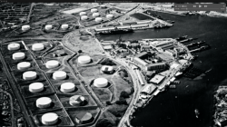
Conceived in the early years of World War II as a plan to bury four fuel containers horizontally in a hillside at the U.S. Navy facility at Pearl Harbor, Hawaii, the Red Hill Underground Fuel Storage Facility ultimately encompassed the design and construction of 20 vertical storage tanks - each large enough to contain a 20-story building - buried in the volcanic hillside and connected by tunnels to a harbor-side pumping station more than two-and-a-half miles away.
YearAdded:
Image Credit: Courtesy Wikicommons/Leslie Nelson (CC BY-SA 4.0)Image Caption: Above-ground fuel storage tanks at Pearl Harbor prior to the construction of Red Hill.Era_date_from: 1943
1994
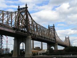
When opened in 1909, the Queensboro Bridge had the two longest steel cantilever spans in the world - 1,182 feet from Manhattan to Blackwell's Island and 984 feet from Blackwell's Island to Queens. These would remain the world's longest cantilever spans until the completion of the Quebec Bridge in 1917. The Queensboro Bridge has an overall length of 3,724.5 feet. It originally carried two elevated railway lines, two trolley lines, six carriage lanes and two pedestrian walkways.
YearAdded:
Image Credit: Courtesy Flickr/reivax (CC BY-SA 2.0)Image Caption: Queensboro BridgeEra_date_from: 1909
2009
The bridge is immense, not only in length and weight but in width. At 67 feet wide, it can accommodate two sets of railway tracks, two sets of streetcar tracks and two roadways.
It took three tries and cost 89 lives, but the city of Quebec was determined to compete with provincial rival Montreal for commercial rail traffic in the late 19th century. The solution was a rail bridge across the St. Lawrence River requiring a single cantilever span 1,800 feet long - the longest ever attempted.
YearAdded:
Image Credit: Courtesy Wikipedia/Sebastien Savard (CC BY-SA 2.5)Image Caption: Quebec BridgeEra_date_from: 1917
1987
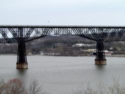
A bridge across the Hudson at or near Poughkeepsie was planned starting in the early 1870s to primarily carry coal from the coalfields of northeastern Pennsylvania to New England. At the time there were no bridges between Albany and New York Harbor. Horatio Allen, soon to be President of the ASCE, was its first Chief Engineer. He designed a multiple span suspension bridge. Later the American Bridge Company started construction on a five span bridge but went bankrupt before it completed the first pier foundations.
YearAdded:
Image Credit: Courtesy Flickr/bobistraveling (CC BY 2.0)Image Caption: Poughkeepsie-Highland BridgeEra_date_from: 1888
2009
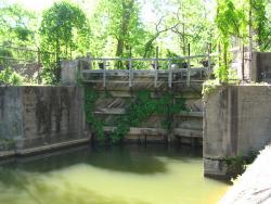
These canals and locks are a part of the first extensive system of canal and river navigation works undertaken in the United States. The idea for the canal was proposed by George Washington, when, as an engineer, surveyor and military emissary for Virginia, he saw the need for a trade route west beyond the Allegheny Mountains. In order to do create this route, it was necessary to try to tame the Potomac River which was a wild, unruly stream which only the hardiest of rivermen ever attempted.
YearAdded:
Image Credit: Courtesy Flickr/Rudi Riet (CC BY-SA 2.0)Image Caption: Potowmack Canal and LocksEra_date_from: 1799
1970
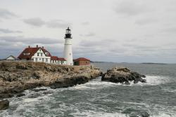
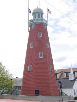
The Portland Head Light was the first lighthouse to be constructed in Maine and the first one completed and put into service by the Federal government under the Lighthouse Act of 1789, which moved to place all lighthouses under federal control. While work had begun on the lighthouse in 1787 by the State of Massachusetts which, at that time, had jurisdiction over Maine, it was completed by the Federal government. When this lighthouse was being built, Portland was the sixth largest port in the country, the closest port to Europe and had significant trade with the Caribbean.
YearAdded:
Image Credit: Courtesy Flickr/Bernt Rostad (CC BY 2.0)Image Caption: Portland Head LightEra_date_from: 1787
2002
The Portland Observatory was built in 1807 by Captain Lemuel Moody to serve as a communication station for Portland Harbor. Portland Observatory was one of the earliest marine signal stations in the United States, and it is the last known to survive. The Observatory's location on Munjoy Hill gave it a clear view of vessels approaching Portland Harbor. The Observatory contributed to the prosperity of Portland Harbor as a vital center of maritime commerce during the "Golden Age of Sail."
YearAdded:
Image Credit: Courtesy Wikipedia/Econrad (CC BY-SA 3.0)Image Caption: Portland ObservatoryEra_date_from: 1807
2006
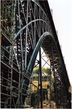
Built to cross one of the steepest valleys along the Douro River, the Ponte Maria Pia was the first major work to emerge from the French firm of Gustav Eiffel and Company, establishing Eiffel as an important bridge designer and civil engineer of his day. Resting on a parabolic arch spanning 160 meters, the Ponte Maria Pia was the longest iron arch bridge in the world at the time of its construction. The bridge's latticework construction reflects the later design of the well-known Eiffel Tower, erected in Paris to commemorate the International Exposition of 1900.
YearAdded:
Image Credit: Courtesy Flickr/Kate Watkiss (CC BY 2.0)Image Caption: Ponte Maria Pia BridgeEra_date_from: 1877
1990
Innovations
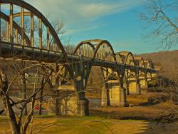
When this 1,850-foot concrete-arch highway bridge was built on the White River in a remote region of northern Arkansas - prior to the construction of upriver, flood-control dams - flash floods occurred frequently, sometimes causing the water to rise as much as one foot per hour. Construction…
Read More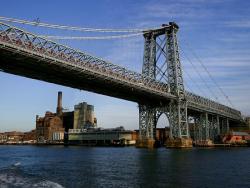
When opened in 1903, the 1,600 foot long main span of the Williamsburg Bridge was the world's longest suspension span, surpassing the nearby Brooklyn Bridge by only 4.5 feet. The Williamsburg Bridge remained the world's longest suspension bridge span for 21 years until the opening of the Bear…
Read More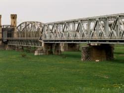
Conceived as one of the major structures on the Prussian Eastern Railway, the Old Wisla Bridge at Tczew originally consisted of six wrought iron spans. Due to Germany's invasion of Poland at the beginning World War II in 1939, only three original spans remain today. These remaining spans…
Read More
With the discoveries of South Africa's diamonds in the 1860s and gold in the 1880s, immigrants flooded into Cape Town and changed it into a major commercial center. Unfortunately, its water supply had not kept pace with the population growth. After several droughts and years of inadequate water…
Read More
The first Zuiderzee Enclosure Dam ran from North Holland to the island of Wieringen, successfully barring the sea for over 50 years and protecting a large area north of Amsterdam. The total Zuiderzee project was the largest land reclamation effort in the Netherlands, developed over a period of…
Read More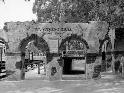
Historically, a camino real (Royal Road) is defined as a road that connects Spanish capital with Spanish capital, a distinction not shared with roads connecting ordinary Spanish or Indian villages. The term Camino Real implied that the status and privileges granted to the villas and capitals it…
Read More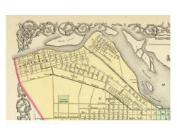
Chartered in 1825, the Louisville and Portland Canal Company was authorized to construct a canal around the rapids called the "Falls of the Ohio." Construction started on March 1, 1826. The canal and first generation of locks were completed in 1830. As originally constructed, the canal was 1.9…
Read More
Between 1825 and 1847 the State of Ohio constructed 1,000 miles of canals and feeder canals, 33,000 acres of reservoir surface area, 29 dams across streams, 294 lift locks, 44 aqueducts and many smaller structures at a cost of about 16 million dollars. The network of navigable canals provided a…
Read More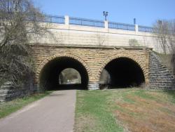
Designed by William A. Truesdell, a railroad engineer, the Seventh Street Improvement Arches celebrates the engineering application of mathematics to improve living conditions.
The construction of these arches presented a number of challenges. Since Seventh Street intersected the St.…
Read More
Constructed to provide a safe, potable water supply for the citizens of Chicago, Ellis Chesbrough's Chicago Water Supply System was the first major system to utilize offshore intake systems. The system includes the landmark Chicago Water Tower and the Chicago Avenue Pumping Station. Its…
Read More
The City Plan of Philadelphia is a seminal creation in American city planning in that it was the first American City Plan to provide open public squares for the free enjoyment of the community and a gridiron street pattern featuring streets of varying widths: wide main streets and narrower side…
Read More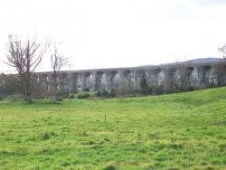
The Dublin to Belfast Rail Link established a vital connection between the capitals of Northern Ireland and the Republic of Ireland. The line's most notable engineering feature was the 1,760-foot-long Boyne Bridge; it represented one of the earliest uses of calculated stresses, the first…
"Eads had to succeed in the face of conventional wisdom which doomed him to disaster. Entrenched authorities not only completely dismissed his theories, but pointed to the indifferent European experiences with what he proposed."
- ASCE Landmark Nomination Proposal, 1982

The East Maui Irrigation System is Hawaii's most dramatic water story. It began with the construction of the Old Hamakua Ditch built between 1876 and 1878. This privately financed, constructed and managed irrigation system was one of the largest in the United States. It eventually included…
El Camino Real (literally, "the royal road") is the oldest and longest historical trail in the Western Hemisphere. The transportation link has, through the centuries, been called various names, including El Camino Real de Tierra Adentro (literally, "the road to the interior" because the U.…
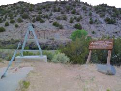
A tiny village on the Rio Grande River in northern New Mexico became the training center for the first American hydrographers and provided the first stream-gauging operations of the U.S. Geological Survey. To plan any water system, it is necessary to know the amount of water flowing in the…
Read More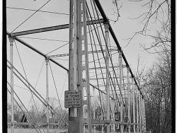
"Fink's truss design was one of a number of early patented solutions to [the problem of how] to carry a massive, moving weight (a train) over long spans (to avoid the expense of building piers and obstructing waterways) on easily erected bridges (often in rough terrain) with good long-term…
Read More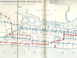
In the 19th century, New York City was a burgeoning industrial and commercial metropolis - the largest city in the United States and second largest in the world. As the city's population increased, people began to call for construction of an underground railway. Many unusual engineering…
Read More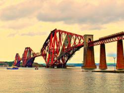
"The majestic Forth Bridge ... symbolises the tremendous achievements of Victorian engineers and the immense strides made in the technique of bridge design and construction since the dawn of the Railway Age..."
- Derrick Bennett, Bridges: Great Buildings of the World
Throughout…
Read More
"Some of New Hampshire's most aesthetically pleasing yet least appreciated structures are stone arch bridges."
From: Stone Arch Bridges of the Contoocook River Valley, New Hampshire Profiles, May, 1978 by Raymond Gibson
These five bridges, Carr Bridge (mid 1800's), Gleason…
