
Water wheels have been used to power mills and pumps for centuries. However, the traditional water wheel was inefficient: water hitting a bucket would splash back against the next bucket, slowing the wheel. This is especially true when water is delivered to the buckets under very high pressure.
Civil
YearAdded:
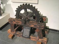
Image Credit: Public Domain (Author's Choice)Image Caption: Pelton Impulse Water WheelEra_date_from: 1878
1973
No image dominates the Midwestern landscape like the monolithic grain elevator, whose present shape and construction owe much to grain company operator Frank Peavy and architect-builder Charles Haglin.
Wanting to improve on the flammability and cost of traditional wood-cribbed construction, Peavy speculated that reinforced concrete, in its infancy at the turn of the century, would outperform other materials. But critics feared that the elevator would collapse due to the vacuum created when grain was emptied from the air-tight structure.
YearAdded:
Image Credit: Courtesy Wikipedia/Original Uploader was Elkman (CC BY-SA 3.0)Image Caption: Peavey-Haglin Concrete Grain ElevatorEra_date_from: 1900
1983
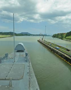
The United States became interested in a water route through the Panamanian isthmus in the mid-1850s, but it was the French who first attempted to build the Panama Canal. Led by Ferdinand de Lesseps, builder of the Suez Canal in Egypt, the French began the project in 1876. Conditions were brutal: rampant yellow fever and malaria; massive landslides and flooding; sweltering heat; and construction equipment that was too light for the job.
YearAdded:
Image Credit: Courtesy Flickr/Naval Surface Warriors (CC BY-SA 2.0)Image Caption: Panama CanalEra_date_from: 1914
1984
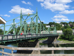
The crossing of the Delaware River at Easton, Pennsylvania, provided a central link in travel from the northeastern seaboard to America's inland territories throughout the 18th and early 19th centuries. From 1806 to the mid-1890s, travelers used a landmark wooden structure built by noted bridge-builder Timothy Palmer. By the 1880s, however, Palmer's three-span covered bridge could no longer handle the demands of traffic generated by new trolley lines.
YearAdded:
Image Credit: Public Domain (National Park Service)Image Caption: Northampton Street BridgeEra_date_from: 1896
1997
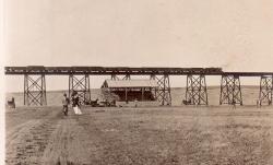
The Northern Pacific High Line Bridge No. 64, built between 1907 and 1908, has continued to perform yeoman service in the uninterrupted flow of the Nation's commerce. Nearly, 100 years after this bridge officially opened, it still carries 125-ton car unit coal trains, double stack container trains, lumber, and refined products at train speeds of 50 m.p.h.
YearAdded:
Image Credit: Original Photo: Public Domain; Produced prior to 1/1/1923Image Caption: Northern Pacific High Line Bridge No 64Era_date_from: 1908
2004
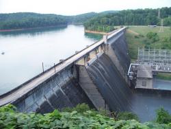
Norris Dam impounds the Clinch River, a mountain tributary of the Tennessee River. The facility stands as a tribute and symbol of the birth of the Tennessee Valley Authority (TVA). Given broad jurisdiction over resource development in the watershed (a 40,000-square-mile basin comprising parts of Virginia, North Carolina, Georgia, Alabama, Mississippi, Kentucky, and Tennessee), the TVA was formed to plan for flood control, improve navigation, and produce hydroelectric power.
YearAdded:
Image Credit: Courtesy Flickr/vosburg09 (CC BY 2.0)Image Caption: Norris DamEra_date_from: 1936
1986
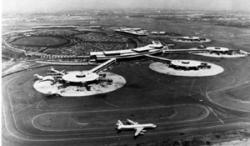
In May 1927, the same month of Charles A. Lindbergh's famous transatlantic flight from New York to Paris, a fact-finding commission appointed by the U.S. Secretary of Commerce concluded that Newark would be the ideal location for an airfield to serve the greater New York/New Jersey metropolitan area.
Civic leaders wasted no time; construction began on the Newark Airport in January 1928. Nine months and $1,750,000 later, 68 acres of soggy marshland had been filled and converted to an airport.
YearAdded:
Image Credit: Courtesy sections.asce.orgImage Caption: The Newark Airport, a pioneering major airport with its 1,600-foot runway, was one of the first hard surfaced runways to be constructed at any municipal airport in the United States and, as such, it served as prototype for today's modern airport runway.Era_date_from: 1928
1978
Delaware 19709New CastleState: DECountry: USAWebsite: http://www.asce.org/Project/New-Castle-Ice-Harbor/Creator: Delafield, Richard
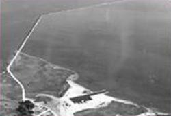
In 1794, the Delaware legislature authorized a lottery to fund the erection of ice piers in the harbor at New Castle. The ice harbor was designed to protect anchored ships from storms and ice. At the time, New Castle served as the principal winter port for ships from the Port of Philadelphia because ice on the Delaware River posed such a serious hazard to the wooden-hulled vessels. The harbor was the first of its type on the river and the last one to be maintained as the need for them declined. It served as a model for the other four harbors constructed in the area.
YearAdded:
Image Caption: New Castle Ice HarborEra_date_from: 1794
1986
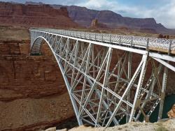
Navajo Bridge spans Marble Canyon, 470 feet above the Colorado River in Grand Canyon National Park. It was considered the highest steel arch bridge in America when completed.
The Navajo Bridge (also known as the Grand Canyon Bridge) was built in 1929 by the Arizona Highway Department and provided a vital transportation link over the Grand Canyon between northern Arizona and southern Utah. Construction commenced by building on one side of the canyon, then on the other, until the two sides met in the middle.
YearAdded:
Image Credit: Courtesy Flickr/Frank Kovalchek (CC BY 2.0)Image Caption: Navajo BridgeEra_date_from: 1929
1997
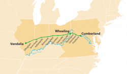
The National Road was the first interstate highway in the United States, and the first roadway to be financed with federal money. Authorized by Congress during the administration of Thomas Jefferson in 1806, the road was built over time and in sections from Cumberland, Maryland, westward through the states of Pennsylvania, Virginia (now West Virginia), Ohio, and Indiana, before terminating at the state capital of Vidalia, Illinois.
YearAdded:
Image Credit: Courtesy Wikipedia/Citynoise (CC BY-SA 2.5)Image Caption: National RoadEra_date_from: 1811
1976
Innovations
The voyage of Captain George Vancouver, 1791 -1795, was commissioned by the British Admiralty to map in detail the west coast of North America from Mexico to Alaska and to meet with Spanish authorities on the coast to enforce the terms of the Nootka Sound Convention of 1790.
Departing…
Read More
The Royal Colonial Boundary of 1665 was decreed by England's King Charles II to demarcate his American colonies. It provided a survey from the Atlantic Ocean to the Mississippi River along 36 degrees, 30 minutes north latitude. The boundary now serves to divide Virginia from North Carolina and…
Read More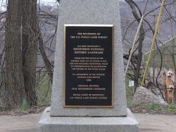
The "Land Ordinance of 1785" required that U.S. lands in the public domain be surveyed before sale, and that the surveys be made in accordance with a consistent, integrated system of lines grid-oriented to a true meridian (north-south reference line) and base line (east-west reference line),…
Read More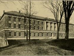
Amos Eaton and Stephen Van Rensselaer founded the Rensselaer School for "the application of science to the common purposes of life" in 1824. Eaton had practiced surveying as a teenager building his own compass and chain and wrote an early book on surveying. Later he studied law before becoming…
Read More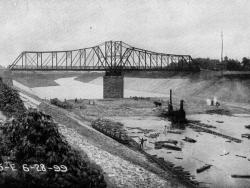
Until 1900, the Chicago River drained into Lake Michigan, along with all the sewage from the city; and the Des Plaines River west of Chicago emptied into the Illinois River, which eventually flows to the Mississippi. Chicago residents drew their drinking water from polluted areas of the lake…
Read More
On October 23rd, 1852 a notice was sent to practitioners of civil engineering in and near New York City requesting their participation in developing an association that would serve the professionals who design and construct America's built environment. Twelve men responded to this invitation,…
Read More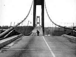
Taken together, the 1940 and 1950 Tacoma Narrows bridges mark a significant turning point in the design of long-span suspension bridges. The original 1940 structure was designed with one of the shallowest and narrowest stiffening elements of any long-span suspension bridge yet built. The…
Read More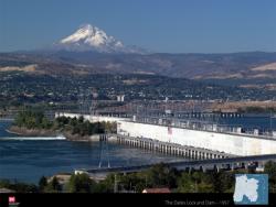
The Dalles Lock and Dam was one of the largest, most complete, and complex multipurpose projects of its kind in the United States at the time of its construction. It provided an example for future projects benefitting navigation, recreation, water for irrigation and hydropower, fish migration,…
Read More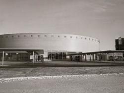
The roof system of this building, designed by Lev Zetlin and opened in 1960, was the first of its kind in the world. Before the mid-1950's, the use of long-span cable structures was generally limited to suspension bridges. The only other significant cable roof structure preceding the Utica…
Read More
The Union Bridge was built in 1804 by Theodore Burr and was the first to cross the lower section of the Hudson River connecting Waterford and Lansingburg, New York. The wooden bridge's key feature was the arch that started below the deck at the abutments and ran near the top of the top chord at…
Read More
With the dawn of the automobile age at the beginning of the Twentieth Century, the entire nation started to demand better roads. In the 1910s, motorists and businessmen in Utah became aware of the possibilities of tourism as a business. Soon the state of Utah and the federal government responded…
Read More
In the 1940s and 1950s, New Orleans experienced growth. Unfortunately, access from the north to the City continued to be limited by Lake Pontchartrain. Driving around the Lake was a time consuming effort. During this time period, a renewed interest developed to provide a direct connection across…
Read More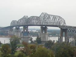
"It remains today one of the great bridge engineering accomplishments for railway and highway bridges built in the country."
- Historic American Engineering Record, Southeast Regional Office, National Park Service, U.S. Department of the Interior, 2005
By the late 1880s, New…
Read More
Spearheaded by Chief Engineer William J. Wilgus and constructed under challenging conditions with no interruption of existing train service, Grand Central Terminal was a triumph of innovative engineering in the design of urban transportation centers. Its novel, two-level station, made possible…
Read More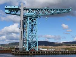
The Titan is a 200-ton electrically driven hammerhead cantilever crane, the earliest survivor of this type. It is now all that remains of the once great John Brown Shipyard in Clydebank near Glasgow where many of the world's great ships were built. Designed and constructed by Sir William Arrol…
Read More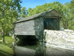
Ackley Bridge is an excellent example of a multiple kingpost truss and a noteworthy early example of covered bridge preservation efforts in the United States. Built in 1832 by Joshua Ackley (b.1805) and Daniel Clouse (b.1812), Ackley Bridge originally spanned Enslow’s Branch of Wheeling Creek…
Read More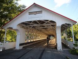
The Ashuelot Covered Bridge is located at the center of Ashuelot, NH. It is a Town lattice truss bridge, spanning the Ashuelot River in a roughly north-south orientation. It consists of two spans with a total length of 178 feet (54 m). The total width of the bridge is 29 feet (8.8 m), and has a…
Read More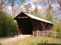
Bunker Hill Bridge is the only surviving Haupt truss bridge in the U.S. and one of only two surviving covered bridges in North Carolina. Patented in 1839, the Haupt truss featured diagonal braces spanning multiple panels, which was an attempt to eliminate the cross-strain found in lattice truss…
Read More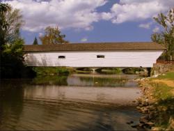
Doe River Bridge is a fine example of a timber Howe truss, one of the most widely-used timber bridge designs. Built in 1884, this structure played an integral role in the development of the City of Elizabethton, Tennessee, and it is a rare example of a covered bridge that survives in an urban…
Read More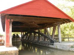
Duck Creek Aqueduct is a rare surviving example of a covered timber aqueduct. It was one of several similar structures on the Whitewater Canal, which operated between the Whitewater Valley and the Ohio River from 1839 to 1865. After being displaced by the railroad, the canal supplied hydraulic…
Read More